

Scales
Campground
2.1 mi from the trail
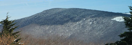
First Peak is a summit of 4,610 feet in Virginia's Little Wilson Creek Wilderness, part of the Mount Rogers National Recreation Area within the George Washington and Jefferson National Forest. The nearest town is Troutdale, about 3 miles away. Summer and early fall are the most comfortable times to go. Typical averages from a nearby weather station show July highs around 79°F and September highs near 72°F, and the summit sits higher than that station, so expect cooler temperatures up top. Hightree Rock Trail and Kabel both start about half a mile away, and Bearpen Trail is roughly 1.3 miles off. For an overnight, Old Virginia Group Horse Camp is about 3.3 miles away.
Where it is: Little Wilson Creek Wilderness · Mount Rogers National Recreation Area
Near: Marion
Best months: April–October. Best months have typical highs of 55–85 °F, lows of 30 °F or warmer (32 °F where the station doesn't record snow), at most one snowy day and no more than 12 wet days.
Jan
41°
22°
Feb
45°
25°
Mar
52°
31°
Apr
62°
41°
May
69°
52°
Jun
76°
59°
Jul
79°
63°
Aug
77°
61°
Sep
72°
55°
Oct
63°
44°
Nov
54°
35°
Dec
46°
27°
Typical high / low (°F) and days with rain or snow, 1991–2020. Measured at Elk Creek 4ssw, VA, 14.4 mi away at 3,439 ft. The station sits about 1,200 ft lower than this place, so expect it a little cooler here. This station doesn't record snowfall. Source: NOAA NCEI U.S. Climate Normals 1991–2020.
Been here? Tell people how it was.
We don't know of a mapped trail or route to the summit of First Peak. Plan the approach with local maps, a guidebook or a local guide, and check conditions before you go.
 Old Virginia Group Horse CampCampingPhoto: Recreation.gov (RIDB) / public domain3.3 mi
 Old Orchard a.t. ShelterCampingPhoto: Famartin, CC BY-SA 4.0 (via Wikimedia Commons)3.8 mi
 Three Top MountainSummitPhoto: James St. John, CC BY 2.0 (via Wikimedia Commons)~30 min drive
 Mount JeffersonSummitPhoto: Matthew Applewood, CC BY-SA 3.0 (via Wikimedia Commons)~30 min drive
 Howard KnobSummitPhoto: Bigmacthealmanac, CC BY-SA 4.0 (via Wikimedia Commons)~55 min driveMount RogersSummitPhoto: USDA-FS, Public domain (via Wikimedia Commons)~9 min drive
Also worth it near here
Daily highs and lows, wind and the chance of precipitation at the summit for the next 7 days, from the Open-Meteo model.
4,610 ft (1,405 m).
We don't know of a mapped trail or route to the summit. Plan the approach with local maps, a guidebook or a local guide.
Questions about First Peak: conditions, access, timing. Answers say when something isn't known.
Scales
Campground
Log House Trading Post and Restaurant
Restaurant
Mountain Farm Life Museum
Museum
Places © OpenStreetMap contributors
More in Jefferson