Thomas Knob a.t. Shelter
Campground
Campground · 0.5 mi from the trail
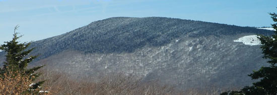 Photo: USDA-FS, Public domain (via Wikimedia Commons)
Closure in the area
There's a closure order in George Washington and Jefferson National Forest. It doesn't name Mount Rogers, so check the source for the area it covers (2 listed).
Enchanted Creek Road (National Forest System Road 1881) will be closed for repairs until 12/31/27
Agency closure covering George Washington and Jefferson National Forest · USFS · George Washington and Jefferson National Forest
Bolar Mountain Recreation Area - Twin Ridge Road Closure
Agency closure covering George Washington and Jefferson National Forest · USFS · George Washington and Jefferson National Forest
Prescribed Fire Operations Mount Rogers National Recreation Area- Porter and Little Mountain
Agency alert covering George Washington and Jefferson National Forest · USFS · George Washington and Jefferson National Forest
Road Closures James River and Warm Springs Ranger District
Agency alert covering George Washington and Jefferson National Forest · USFS · George Washington and Jefferson National Forest
Fire Restrictions in place for Appalachian Trail
Agency alert covering Mount Rogers National Recreation Area · Order 08-08-14-26-02 · USFS · Mount Rogers National Recreation Area
As of · Source: USFS · George Washington and Jefferson National Forest. Agencies don't list every closure — check before you go.
Mount Rogers is a summit of 5,729 feet in Virginia's Lewis Fork Wilderness, part of the Mount Rogers National Recreation Area within the George Washington and Jefferson National Forest. The nearest town is Troutdale, about 6.5 miles away. Several routes start close by. The Mount Rogers Spur Trail and the Virginia Creeper Trail Bouldering are each about 0.4 miles away, and the Cabin Ridge hike is about 0.7 miles off. For an overnight base, Grindstone Campground sits about 1.9 miles away.
Thomas Knob a.t. Shelter
Campground
Log House Trading Post and Restaurant
Restaurant
Mountain Farm Life Museum
Museum
Places © OpenStreetMap contributors
More in JeffersonDaily highs and lows, wind and the chance of precipitation at the summit and route start for the next 7 days, from the Open-Meteo model.
Elevation from USGS 3D Elevation Program terrain data (about 10 m resolution).
5,729 ft (1,746 m).
One: Mount Rogers Spur Trail.
 Grindstone Family CampgroundCampingPhoto: Famartin, CC BY-SA 4.0 (via Wikimedia Commons)1.9 mi
Source: Roamze catalog (indexable pages within 10 miles, PostGIS distance)
 Three Top MountainSummit · ~28 min drivePhoto: James St. John, CC BY 2.0 (via Wikimedia Commons)
 Mount JeffersonSummit · ~32 min drivePhoto: Matthew Applewood, CC BY-SA 3.0 (via Wikimedia Commons)
 Howard KnobSummit · ~52 min drivePhoto: Bigmacthealmanac, CC BY-SA 4.0 (via Wikimedia Commons)
Also worth it near here
 Thomas Knob a.t. ShelterCamping · Next doorPhoto: Famartin, CC BY-SA 4.0 (via Wikimedia Commons)
 Appalachain Spur TrailHiking · ~5 min drivePhoto: bobistraveling, CC BY 2.0 (via Wikimedia Commons)
 Briar Patch BouldersRock climbing · ~6 min drivePhoto: vastateparksstaff, CC BY 2.0 (via Wikimedia Commons)
