Green Mountain Trail #782
- 4.1 mi
- round trip
- 4,540 ft
- climb
- 6,404 ft
- high point
- Out and back
- route
Is Green Mountain Trail #782 open right now?
Closure in the area
There's a closure order in Darrington Ranger District. It doesn't name Green Mountain Trail #782, so check the source for the area it covers (4 listed).
Miners Fire Closure
Agency closure covering Darrington Ranger District · Order 06-05-26-17 · USFS · Darrington Ranger District
Miner’s Fire Closure Order
Agency closure covering Darrington Ranger District · USFS · Darrington Ranger District
Grand Park 2 Fire Closure Update
Agency closure covering Mt. Baker-Snoqualmie National Forest · Order 06-05-26-16 · USFS · Mt. Baker-Snoqualmie National Forest
Bell Creek Bridge Damaged
Agency closure covering Mt. Baker-Snoqualmie National Forest · USFS · Mt. Baker-Snoqualmie National Forest
Rescission of Shooting Restrictions
Agency alert covering Mt. Baker-Snoqualmie National Forest · USFS · Mt. Baker-Snoqualmie National Forest
As of · Source: USFS · Darrington Ranger District. Agencies don't list every closure — check before you go.
Green Mountain Trail #782 is a 4.06-mile out-and-back hike in Washington's Glacier Peak Wilderness, within the Darrington Ranger District of Mt. Baker-Snoqualmie National Forest. The Forest Service manages the land, and the route is rated expert. The trail is back-loaded, with the high point of 6,404 feet at the start. The climb profile shows a total gain of 4,540 feet and a total loss of 4,540 feet over the 8.1-mile round trip, with the steepest stretch at 0.42 miles in, where the grade reaches 41 percent. Plan for about five hours on the trail. The Old Green Mountain Trail lies just 0.2 miles away, and Downey Creek Trail #768 is about 1.7 miles off. For an overnight base, Sulphur Creek Campground sits roughly 3.1 miles away. Paddlers can find Buck Creek about 3.7 miles from the trail.
Local outfitters
- Triangle Recreation Camp21 mi away
- Cascade Views RV Resort37 mi away
Not on Roamze yet. Their page has how to reach them.
Conditions and forecast on Green Mountain
Daily highs and lows, wind and the chance of precipitation at the summit and route start for the next 7 days, from the Open-Meteo model.
- Old Green Mountain TrailHiking0.2 mi
- DOWNEY CREEKHiking1.4 mi
- Downey Creek Trail #768Hiking1.7 mi
- Sulphur CrCamping3.1 mi
 Sulphur Creek CampgroundCampingPhoto: Recreation.gov (RIDB) / public domain3.1 mi
- Buck CreekCanoeing3.7 mi
- Lime CreekCanoeing4.8 mi
- White Chuck River Boulders (D-Ton)Rock climbing9.5 mi
Source: Roamze catalog (indexable pages within 10 miles, PostGIS distance)
- Old Green Mountain TrailHiking · Next door
- DOWNEY CREEKHiking · ~2 min drive
- Sulphur Mountain Trail #794Hiking · ~6 min drive
- Huckleberry Mountain Trail #780Hiking · ~7 min drive
- Sulphur Creek Trail #793Hiking · ~7 min drive
- CIRCLE PEAKHiking · ~11 min drive
- Suiattle River Trail #784Hiking · ~15 min drive
- BACHELOR CREEKHiking · ~9 min drive
- Buck Creek TrailHiking · ~7 min drive
- Milk Creek Trail #790Hiking · ~15 min drive
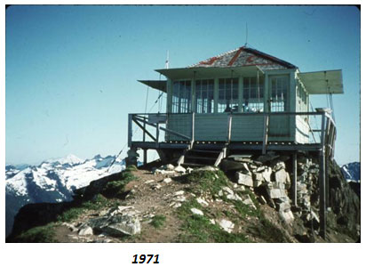
Route details
- Distance
- 4.1 mi round trip
- Climbing
- About 4,540 ft
- Summit
- 6,494 ft
- Difficulty
- Expert
- Time
- About 2 hours
Questions about this route
How long is the Green Mountain Trail #782 on Green Mountain?
About 4.1 mi round trip.
How much elevation gain is on the Green Mountain Trail #782?
About 4,540 ft of climbing round trip.
How hard is the Green Mountain Trail #782?
It is rated expert.
How long does the Green Mountain Trail #782 take?
About 2 hours round trip.
Map and trail data © OpenStreetMap contributors
