Navajo Loop Hike the Hoodoos
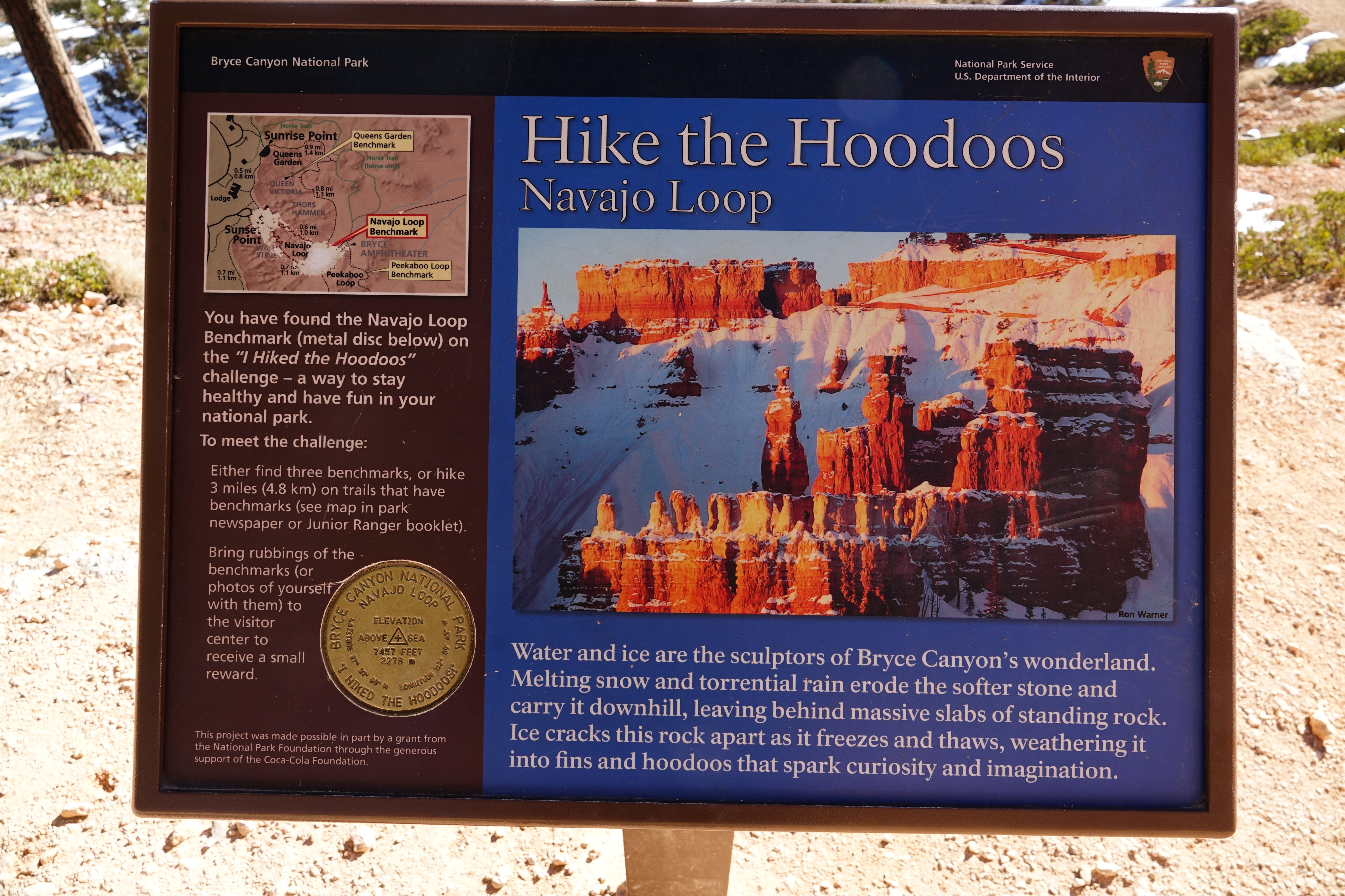 Photo: NPS Photo
- 0.6 mi
- loop
- 506 ft
- climb
- 8,004 ft
- high point
- Loop
- route
- May–Oct
- best months
Is Navajo Loop Hike the Hoodoos open right now?
Closure in the area
There's a closure order in Bryce Canyon National Park. It doesn't name Navajo Loop Hike the Hoodoos, so check the source for the area it covers.
Trail Closures Due to Recent Weather
Park closure covering Bryce Canyon National Park · NPS · Bryce Canyon National Park
Current Fire Restrictions
Park alert covering Bryce Canyon National Park · NPS · Bryce Canyon National Park
As of · Source: NPS · Bryce Canyon National Park. Agencies don't list every closure — check before you go.
I Hiked the Hoodoos Hiking is great exercise and Bryce Canyon's "I Hiked the Hoodoos!" program is not just hiking, it's also a scavenger hunt with a special reward! 1. Hike a minimum of 3 mi / 4.8 km, or find at least 3 benchmarks and complete steps 2 through 4 below. 2. Each individual must have either a pencil rubbing of the benchmark (see Jr. Ranger Book) or a"selfie"with the benchmark. 3. Only special "I Hiked the Hoodoos" benchmarks qualify for the reward. 4. Rewards are available at the Visitor Center! See your park newspaper or Junior Ranger book for more information. Benchmarks are located on Mossy Cave, Rim Trail, Tower Bridge, Queen's Garden, Navajo Loop, Peekaboo Loop, Sheep Creek, and the Bristlecone Loop trails.
Local outfitters
- Ruby's Inn Bryce Canyon RV Park & Campground3 mi away
- Bryce Canyon Horseback Tours4 mi away
Not on Roamze yet. Their page has how to reach them.
- Nearby · Peek-A-Boo Loop Hike the Hoodoos · Navajo Loop Trailhead wayside · Rim Trail Inspiration Point Trailhead
Best time to go · May–Oct
Best time to visit Navajo Loop Hike the Hoodoos
Best months: May–October. Best months have typical highs of 55–85 °F, lows of 30 °F or warmer (32 °F where the station doesn't record snow), at most one snowy day and no more than 12 wet days.
Jan
37° / 17°
6 wet
Feb
39° / 18°
7 wet
Mar
46° / 23°
7 wet
Apr
54° / 29°
6 wet
May
63° / 37°
5 wet
Jun
75° / 45°
4 wet
Jul
80° / 52°
8 wet
Aug
77° / 50°
10 wet
Sep
70° / 42°
7 wet
Oct
58° / 32°
5 wet
Nov
46° / 23°
5 wet
Dec
37° / 17°
6 wet
Typical high / low (°F) and days with rain or snow, 1991–2020. Measured at Bryce Canyon Np Hqrs, UT, 1.6 mi away at 7,890 ft. This station doesn't record snowfall. Source: NOAA NCEI U.S. Climate Normals 1991–2020.
Keep exploring — more trails worth the drive
HIKE
Peek-A-Boo Loop Hike the Hoodoos
Next door
I Hiked the Hoodoos Hiking is great exercise and Bryce Canyon's "I Hiked the Hoodoos!" program is not just hiking, it's also a scavenger hunt with a special reward! 1. Hike a minimum of 3 mi / 4.8 km, or find at least 3 benchmarks and complete steps 2 through 4 below. 2.…
HIKE
Navajo Loop Trailhead wayside
Next door
This popular trail has two sides, one descending into the narrow paths of Wall Street and the other to the erosion-resistant Two Bridges and Thor's Hammer. Hikers can also connect to the Peekaboo Loop and Queen's Garden Trail to create larger loops. See the Visitor Guide for i…
HIKE
Rim Trail Inspiration Point Trailhead
Next door
The Rim Trail Difficulty: Varies (Easy to Moderate) Total Distance: 5.5 miles (8.9 km) Ascent/Descent (South to North): 1,330 feet (405 m) / 1,825 feet (556 m) Average time: 3-4 hours The 5.5 mile (8.9 km) Rim Trail begins in the south at Bryce Point and ends in the north at…
HIKE
Rim-Trail Inspiration Point wayside
Next door
Rim Trail: Inspiration Point Orientation Hikers can enjoy an easy 0.7-mile (1.2 km) walk north to Sunset Point above the Silent City, or a moderate 1.5-mi (2.4 km) hike south along steep cliffs to Bryce Point. When the shuttle is running, it can be used to enjoy one-way…
HIKE
Navajo Loop Trailhead
Next door
Navajo Loop Difficulty: Moderate Total Distance: 1.3 miles (2.2 km) Elevation change: 550 feet (168 m) Average time: 1-2 hours The iconic Navajo Loop Trail begins and ends at Sunset Point, travelling by switchbacks down between narrow walls of colorful limestone with views…
 Photo: IamtheDarkRanger, CC BY 3.0 (via Wikimedia Commons)
Queens Garden Trail
Next door
0.84-mile out-and-back trail in Utah with 96 ft elevation gain.
HIKE
Queens Garden Hike the Hoodoos
Next door
I Hiked the Hoodoos Hiking is great exercise and Bryce Canyon's "I Hiked the Hoodoos!" program is not just hiking, it's also a scavenger hunt with a special reward! 1. Hike a minimum of 3 mi / 4.8 km, or find at least 3 benchmarks and complete steps 2 through 4 below. 2.…
HIKE
Rim Trail Sunset Point Trailhead
Next door
The Rim Trail Difficulty: Varies (Easy to Moderate) Total Distance: 5.5 miles (8.9 km) Ascent/Descent (South to North): 1,330 feet (405 m) / 1,825 feet (556 m) Average time: 3-4 hours The 5.5 mile (8.9 km) Rim Trail begins in the south at Bryce Point and ends in the north at…
HIKE
Tower Bridge and Fairyland Loop Trailheads
~2 min drive
Tower Bridge Trail Difficulty: Moderate Total Distance: 3.0 miles (4.8 km) Elevation change: 802 feet (245 m) Average time: 2-3 hours Similar in difficulty to the Queen's / Navajo Combination loop, but far less travelled, the Tower Bridge trail provides excellent views of…
HIKE
Wall of Windows Hike the Hoodoos
~1 min drive
I Hiked the Hoodoos Hiking is great exercise and Bryce Canyon's "I Hiked the Hoodoos!" program is not just hiking, it's also a scavenger hunt with a special reward! 1. Hike a minimum of 3 mi / 4.8 km, or find at least 3 benchmarks and complete steps 2 through 4 below. 2.…


