Lower Spring Canyon Trailhead
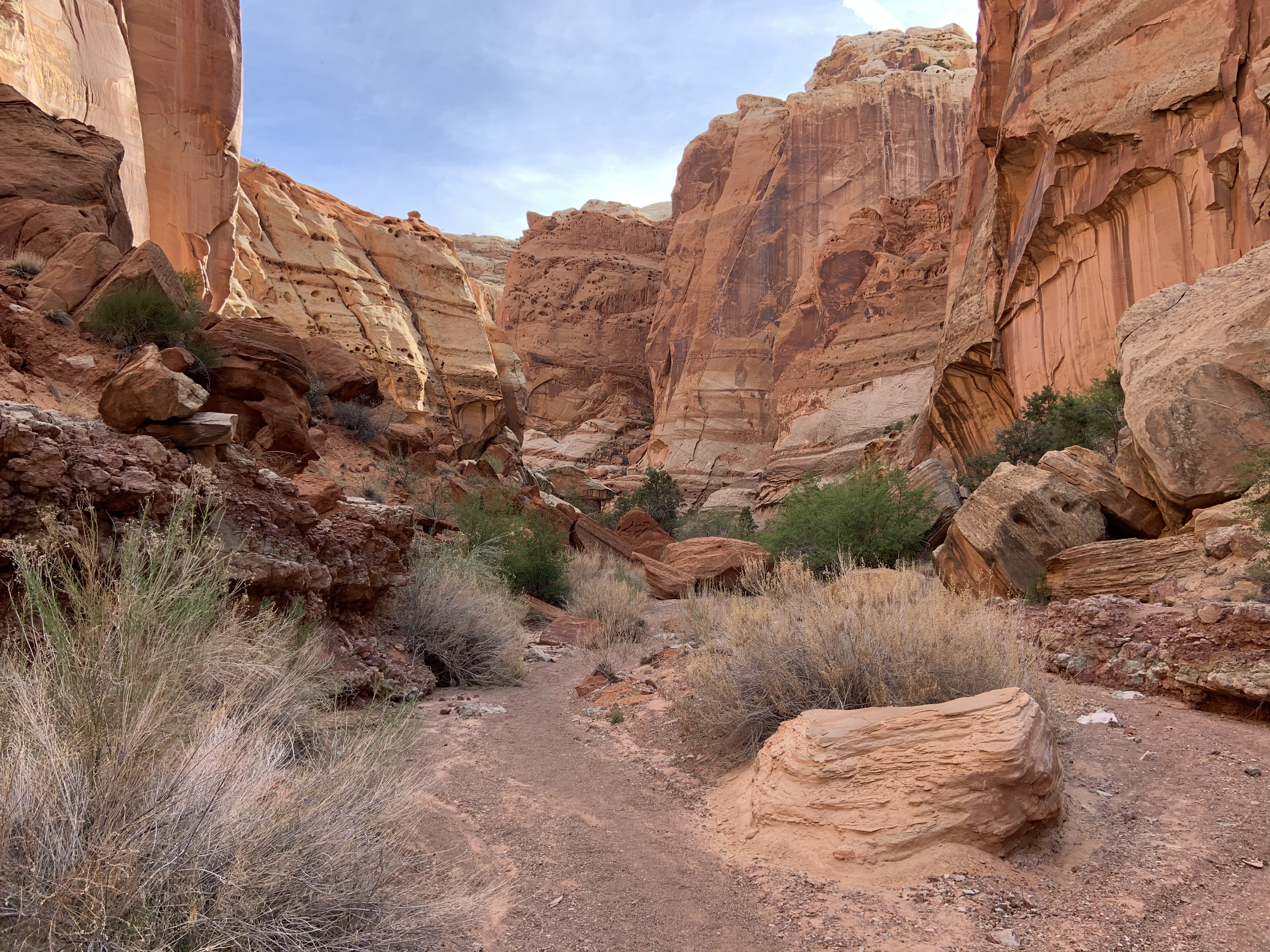 Photo: NPS
- 7.4 mi
- round trip
- 704 ft
- climb
- 5,868 ft
- high point
- Out and back
- route
- Mar–May, Sep–Oct
- best months
Is Lower Spring Canyon Trailhead open right now?
Alert in the area
The National Park Service lists 2 alerts for Capitol Reef National Park.
Elevated E. Coli levels - Fremont River and Sulphur Creek
Park alert covering Capitol Reef National Park · NPS · Capitol Reef National Park
Monsoon Season & Flash Floods
Park alert covering Capitol Reef National Park · NPS · Capitol Reef National Park
As of · Source: NPS · Capitol Reef National Park. Agencies don't list every closure — check before you go.
Up the road and across the river is the mouth of Lower Spring Canyon. This gorge extends behind the cliffs all the way west toward Chimney Rock. The trek twists through a towering tunnel of sandstone for over 7 miles (11.3 km). Lower Spring Canyon is one of many popular backpacking routes in the park. Capitol Reef is renowned for its wilderness exploration opportunities. Around 90% of the park is managed like wilderness. This means the Park Service minimizes human interference. Wilderness management safeguards the ecological health, research potential, and recreational value of the land. We tend to think of wilderness as “untouched by humans.” But numerous indigenous cultures have been a part of this land for millennia. Much of what we think of as “wild” has been tended and shaped by humans for generations. Interested in backpacking? Please note that a free backcountry permit—available at the visitor center—is required for any overnight stays outside the designated campgrounds. Backpacking requires extensive preparation and desert survival skills. Narrow canyons like Spring Canyon and Grand Wash are susceptible to flash floods. Always check the weather forecast before you begin your adventure.
Local outfitters
- Sand Creek RV Park & Campground13 mi away
- Muddy Creek Mining Co.27 mi away
Not on Roamze yet. Their page has how to reach them.
Best time to go · Mar–May, Sep–Oct
Best time to visit Lower Spring Canyon Trailhead
Best months: March–May and September–October. Best months have typical highs of 55–85 °F, lows of 30 °F or warmer (32 °F where the station doesn't record snow), at most one snowy day and no more than 12 wet days.
Jan
41° / 21°
3 wet · 2 snow
Feb
47° / 26°
4 wet · 1 snow
Mar
57° / 34°
4 wet · 1 snow
Apr
65° / 39°
4 wet
May
74° / 48°
5 wet
Jun
86° / 58°
4 wet
Jul
91° / 65°
7 wet
Aug
88° / 63°
8 wet
Sep
80° / 55°
6 wet
Oct
66° / 43°
4 wet
Nov
51° / 30°
3 wet · 1 snow
Dec
40° / 21°
3 wet · 2 snow
Typical high / low (°F) and days with rain or snow, 1991–2020. Measured at Capitol Reef Np, UT, 3.5 mi away at 5,500 ft. Source: NOAA NCEI U.S. Climate Normals 1991–2020.
Keep exploring — more trails worth the drive
 Photo: Greg Willis from Denver, CO, usa, CC BY-SA 2.0 (via Wikimedia Commons)
Golden Throne
~9 min drive
1.84-mile out-and-back trail in Utah with 1,189 ft elevation gain.
 Photo: Shaan Hurley — CC BY 2.0 (via Flickr)
Capitol Gorge Trail
~9 min drive
2.36-mile out-and-back hike in Utah with 937 ft elevation gain.
HIKE
Sulphur Creek Trail
~6 min drive
5.89-mile out-and-back trail in Utah with 2,286 ft elevation gain.
HIKE
Pleasant Creek
~13 min drive
6.79-mile out-and-back trail in Utah with 1,412 ft elevation gain.
 Photo: Frans-Banja Mulder, CC BY 3.0 (via Wikimedia Commons)
Chimney Rock Canyon
~9 min drive
1.46-mile out-and-back trail in Utah with 488 ft elevation gain.
 Photo: mtnscll — CC BY-SA 2.0 (via Flickr)
Sunset Point
~9 min drive
0.39-mile out-and-back trail in Utah with 271 ft elevation gain.
HIKE
Upper Spring Canyon
~18 min drive
7.95-mile out-and-back trail in Utah with 1,803 ft gain.
 Photo: Ken Lund — CC BY-SA 2.0 (via Flickr)
Chimney Rock Loop
~10 min drive
3.09-mile out-and-back trail in Utah with 1,104 ft elevation gain.
 Photo: Greg Willis, CC BY-SA 3.0 (via Wikimedia Commons)
Jailhouse Rock/ Temple Rock
~14 min drive
3.79-mile out-and-back trail in Utah with 363 ft elevation gain.
 Photo: Frans-Banja Mulder, CC BY 3.0 (via Wikimedia Commons)
Cooks Mesa Trail
~18 min drive
8.96-mile out-and-back hike in Utah with 1,384 ft gain/loss.
Also worth it near here
 Photo: Anna Irene, CC BY-SA 2.0 (via Wikimedia Commons)
Pectols Pyramid
~3 min drive
 Photo: The Dye Clan, CC BY-SA 3.0 (via Wikimedia Commons)
Terrible Twos Wall
~3 min drive
 Photo: Aneta Kaluzna, CC BY-SA 2.5 (via Wikimedia Commons)
Hickman Natural Bridge
~3 min drive
BED
Capitol Reef Group Campground
~5 min drive
