Androscoggin River
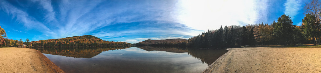
 Photo: Mike Cline, CC BY-SA 3.0 (via Wikimedia Commons)
The Androscoggin River is a canoeing route in New Hampshire, about 1.2 miles from the town of Dummer. The river makes an easy base for a paddling trip in the state's northern corner, with the nearest town close enough to reach supplies and a place to start or end the day. Summer is the most comfortable season for paddling. Typical averages from a nearby weather station in Berlin run from highs around 75°F in June to about 80°F in July, with July also the wettest month at roughly 18 wet days. September cools to highs near 71°F, and winter is cold, with January highs averaging about 27°F. Several other outdoor spots lie within easy reach. The Milan Hill Fire Tower, a cross-country ski destination, is about 2.8 miles away. Hikers can head to Cow Mountain Trail, roughly 4.9 miles off, or Devil's Hopyard, about 7 miles away. Climbers will find the Middle Forist Area just under 10 miles from the river.
Local outfitters
- Northern Waters Outfitters12 mi away
- Clyde River Recreation45 mi away
Not on Roamze yet. Their page has how to reach them.
- Milan Hill Fire TowerCross-country skiing2.8 mi
- Cow Mountain TrailHiking4.9 mi
 Devil's HopyardHikingPhoto: Tony Webster, CC BY-SA 2.0 (via Flickr)7 mi
- Lamphere TrailHiking8.2 mi
- Rogers Ledge Tent SiteCamping8.3 mi
 Middle Forist AreaRock climbingPhoto: Jon Platek, CC BY-SA 3.0 (via Wikimedia Commons)9.8 mi
- Mount ForistRock climbingPhoto: Jon Platek, CC BY-SA 3.0 (via Wikimedia Commons)9.8 mi
- Madigan AreaRock climbingPhoto: Jon Platek, CC BY-SA 3.0 (via Wikimedia Commons)9.9 mi
Source: Roamze catalog (indexable pages within 10 miles, PostGIS distance)
- Androscoggin RiverCanoeing · Next doorPhoto: Mike Cline, CC BY-SA 3.0 (via Wikimedia Commons)
- Boffinger Conservation Area Boat RampBoat launch · Next door
- Androscoggin RiverCanoeing · ~1 min drivePhoto: Mike Cline, CC BY-SA 3.0 (via Wikimedia Commons)
- Cedar Pond Boat AccessBoat launch · ~4 min drive
- Androscoggin RiverCanoeing · ~1 min drivePhoto: Mike Cline, CC BY-SA 3.0 (via Wikimedia Commons)
- Nansen Wayside State Park Boat RampBoat launch · ~11 min drive
- Androscoggin RiverCanoeing · ~1 min drivePhoto: Mike Cline, CC BY-SA 3.0 (via Wikimedia Commons)
- Jericho Mountain State Park Boat RampBoat launch · ~14 min drive
- Androscoggin RiverCanoeing · ~2 min drivePhoto: Mike Cline, CC BY-SA 3.0 (via Wikimedia Commons)
- Success Pond Boat RampBoat launch · ~17 min drive
Best time to visit Androscoggin River
No month here meets our mild-weather rule. Best months have typical highs of 55–85 °F, lows of 30 °F or warmer (32 °F where the station doesn't record snow), at most one snowy day and no more than 12 wet days.
Jan
27° / 2°
12 wet
Feb
30° / 3°
10 wet
Mar
39° / 14°
12 wet
Apr
53° / 27°
13 wet
May
67° / 37°
15 wet
Jun
75° / 47°
16 wet
Jul
80° / 52°
18 wet
Aug
78° / 50°
17 wet
Sep
71° / 42°
14 wet
Oct
57° / 32°
14 wet
Nov
44° / 23°
13 wet
Dec
32° / 11°
14 wet
Typical high / low (°F) and days with rain or snow, 1991–2020. Measured at Berlin Muni Ap, NH, 3.5 mi away at 1,158 ft. This station doesn't record snowfall. Source: NOAA NCEI U.S. Climate Normals 1991–2020.
Map and trail data © OpenStreetMap contributors
