Sage Creek Campground
- May–Sep
- best months
Is Sage Creek Campground open right now?
Closure in the area
There's a closure order in Custer Gallatin National Forest. It doesn't name Sage Creek Campground, so check the source for the area it covers (13 listed).
NFSR #1700 South Plateau Road Closure
Agency closure covering Custer Gallatin National Forest · USFS · Custer Gallatin National Forest
Pine Grove Campground Closure
Agency closure covering Beartooth Ranger District · Order 01-11-82-26-04 · USFS · Beartooth Ranger District
Hyalite Porcupine Buffalo Horn Summer Interim Travel Order and Map and Order # 01-11-00-26-02
Agency closure covering Custer Gallatin National Forest · Order 01-11-00-26-02 · USFS · Custer Gallatin National Forest
Hyalite Porcupine Buffalo Horn Winter Interim Travel Order and Map Order Number: #01-11-00-26-01
Agency closure covering Custer Gallatin National Forest · USFS · Custer Gallatin National Forest
Glacier Lake Road #2421 Closure Order Number: # 01-11-82-26- 01
Agency closure covering Custer Gallatin National Forest · Order 01-11-82-26- · USFS · Custer Gallatin National Forest
As of · Source: USFS · Custer Gallatin National Forest. Agencies don't list every closure — check before you go.
- At 5,534 ft
- Beartooth Ranger DistrictCuster Gallatin National Forest
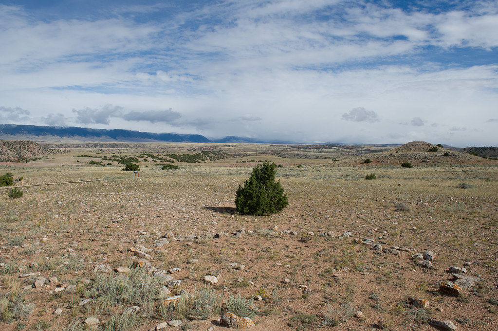
Sage Creek Campground is the only campground in the Pryor Mountains. It is located along the banks of Sage Creek. Big Ice Cave Picnic Ground , and the Bureau of Land Management Pryor Mountain Wild Horse Range are also located in the Pryor Mountains. Numerous motorized trails are located in the Pryor Mountains. See the current year's edition of motor vehicle use map (and legend ) for the area and road closures. There is a 16 day maximum stay in all Beartooth Ranger District campgrounds Camp sites: 12 Host : No Max Trailer Length : 30ft Accessible Facilities: Vault toilets Trash Pickup: No Firewood: No. Don't move firewood to other areas or bring in outside firewood.Prevent the spread of tree-killing insects by obtaining firewood near your destination and burning it there. Reservations : No Reservations. This campground does not use a reservation system, it is managed on a first-come, first-served basis. * Please be advised that there is not consistent potable water here. Call the district office to learn if there is water, or plan ahead and bring your own. Directions from the town of Bridger: [ This route is not advised for campers or horse trailers. High clearance vehicles are recommended ] Drive south of Bridger for 2.8 miles and turn left on Pryor Mountain Road. Drive 12.2 miles until the road dead ends. Turn right to continue on Pryor Mountain Road/ Railroad Grade Rd. Drive 2.8 miles and turn left onto Pryor Mountain Road/ Railroad Grade Rd. In 2.2 miles, turn right onto Railroad Grade Rd. This becomes Forest Road 2500 (Powerline Road). We recommend high clearance vehicles for this section of road. It is rocky and a single track. Drive 6.9 miles and turn right onto Pryor Mountain Road/ Forest Road 2308. Drive 0.3 miles and turn left onto Sage Creek Rd. Drive 0.3 miles to Sage Creek Campground. Roads in the Pryor Mountains become impassable when wet. Powerline Road Access Map For access with campers or trailers , it is recommended to access the Pryor Mountains from the south, via the Crooked Creek Road. From Bridger, drive 21.5 miles south on Hwy-310 to Warren (a conveyeor belt for a quarry goes over the road). Turn left onto Quarry Rd and drive 6.9 miles (at 4.3 miles, the road name changes to Helt Rd). Veer to the right onto Gyp Springs Rd and drive for 7.1 miles. Turn left onto Helt Rd and drive for 0.2 miles, then veer to the right onto Crooked Creek Rd. Drive 6 miles to the Forest Service boundary. Continue another 3.4 miles to Tie Flats. Turn left onto Pryor Mountain Rd (Forest Road 2308) and drive 7.6 miles. Turn right onto Sage Creek Road and drive 0.3 miles to Sage Creek Campground, on your right. [approximate driving time from Bridger, MT: 2.5 hours]. Pryor Mountain Access Map Information: Beartooth Ranger District 6811 Hwy 212 Red Lodge, MT 59068 (406) 446-2103
- Big PryorHiking1.4 mi
- Shriver Peak RoadHiking5.6 mi
- Crater Ice CaveHiking5.7 mi
- Sage CreekCanoeing8.5 mi
- Stockman TrailHiking9.2 mi
Source: Roamze catalog (indexable pages within 10 miles, PostGIS distance)
- Brd2308-012Camping · ~9 min drive
- Brd2097-001Camping · ~10 min drive
- Brd2308c-001Camping · ~10 min drive
- Brd20852-002Camping · ~10 min drive
- Brd20852-001Camping · ~10 min drive
- Brd2308-010Camping · ~17 min drive
- Brd2308-011Camping · ~17 min drive
- Brd2308-009Camping · ~17 min drive
- Brd2308-008Camping · ~17 min drive
- Brd2308-007Camping · ~17 min drive
Best time to visit Sage Creek Campground
Best months: May–September. Best months have typical highs of 55–85 °F, lows of 30 °F or warmer (32 °F where the station doesn't record snow), at most one snowy day and no more than 12 wet days.
Jan
37° / 14°
5 wet
Feb
37° / 14°
5 wet
Mar
46° / 22°
7 wet
Apr
53° / 28°
9 wet
May
62° / 37°
12 wet
Jun
72° / 44°
12 wet
Jul
81° / 50°
10 wet
Aug
81° / 49°
8 wet
Sep
71° / 42°
7 wet
Oct
56° / 31°
7 wet
Nov
43° / 21°
6 wet
Dec
36° / 14°
6 wet
Typical high / low (°F) and days with rain or snow, 1991–2020. Measured at Red Lodge, MT, 34.4 mi away at 5,646 ft. This station doesn't record snowfall. Source: NOAA NCEI U.S. Climate Normals 1991–2020.
Sage Creek Campground
Book on Recreation.gov
