Public Shoreline Beach-Grand Sable Dunes
About
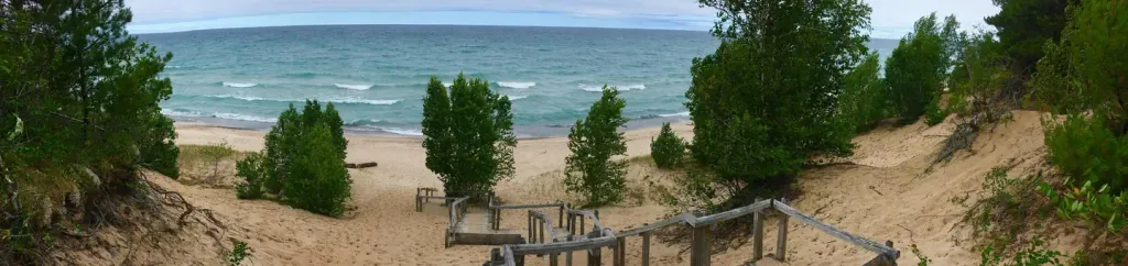
Public Shoreline Beach-Grand Sable Dunes is a beach within Pictured Rocks National Lakeshore in Michigan, about 5.6 miles from the town of Grand Marais. Summer is the most comfortable time to visit. Typical averages from a nearby weather station in Grand Marais show July and August highs around 75°F with lows in the mid-50s, while winter highs stay in the 20s. Grand Sable Lake, a fishing spot, lies about 2.4 miles away. Twelvemile Beach Campground and Cabin is about 6.6 miles off, and the Fox River Pathway is about 8.5 miles away.
Location
Public Shoreline Beach-Grand Sable Dunes
Michigan
Data: US EPA BEACON (Beach Advisory and Closing Online Notification). Source metadata
Facts about this place
When to go
Best time to go: May–Sep. The mildest months here, with typical highs of 61–75°F and lows of 40–56°F.
Typical monthly averages (not a forecast) from the Grand Marais 2 E, MI weather station, 6.3 mi away. High / low in °F.
- Jan24° high14° low
- Feb27° high13° low
- Mar37° high20° low
- Apr47° high28° low
- May61° high40° low
- Jun70° high48° low
- Jul75° high55° low
- Aug75° high56° low
- Sep68° high50° low
- Oct55° high39° low
- Nov41° high29° low
- Dec30° high20° low
Where it is
- Pictured Rocks National Lakeshore · National Park Service
- Nearest town
- Grand Marais, Michigan · 5.6 mi
Source: NPS Land Resources boundaries; USGS GNIS populated places
Conditions
Active alerts for Pictured Rocks National Lakeshore as of Oct 9, 2026:
Sand Point Road Closed 10/1-10/14
Park Closure · posted Sep 29, 2026
Munising Falls Trail Closed Until Further Notice
Park Closure · posted Aug 24, 2026
Source: NPS Alerts API
Nearby
- Grand Sable LakeLake fishing2.4 mi
 Twelvemile Beach Campground and CabinCampingPhoto: Recreation.gov (RIDB) / public domain6.6 mi
- Fox River PathwayHiking8.5 mi
Source: Roamze catalog (indexable pages within 10 miles, PostGIS distance)
Is Public Shoreline Beach-Grand Sable Dunes open right now?
Closure in the area
There's a closure order in Pictured Rocks National Lakeshore. It doesn't name Public Shoreline Beach-Grand Sable Dunes, so check the source for the area it covers.
Munising Falls Trail Closed Until Further Notice
Park closure covering Pictured Rocks National Lakeshore · NPS · Pictured Rocks National Lakeshore
As of · Source: NPS · Pictured Rocks National Lakeshore. Agencies don't list every closure — check before you go.
Best time to visit Public Shoreline Beach-Grand Sable Dunes
Best months: May–October. Best months have typical highs of 55–85 °F, lows of 30 °F or warmer (32 °F where the station doesn't record snow), at most one snowy day and no more than 12 wet days.
Jan
24° / 14°
Feb
27° / 13°
Mar
37° / 20°
Apr
47° / 28°
May
61° / 40°
Jun
70° / 48°
Jul
75° / 55°
Aug
75° / 56°
Sep
68° / 50°
Oct
55° / 39°
Nov
41° / 29°
Dec
30° / 20°
Typical high / low (°F) and days with rain or snow, 1991–2020. Measured at Grand Marais 2 E, MI, 6.3 mi away at 624 ft. We don't have this place's elevation, so higher spots nearby can run cooler. This station doesn't record snowfall. Source: NOAA NCEI U.S. Climate Normals 1991–2020.
