Black Bute Lookout Trail
- 0.8 mi
- loop
- 399 ft
- climb
- 6,672 ft
- high point
- Loop
- route
- Jun–Aug
- best months
Is Black Bute Lookout Trail open right now?
Closure in the area
There's a closure order in Nez Perce-Clearwater National Forest. It doesn't name Black Bute Lookout Trail, so check the source for the area it covers.
Updated 250 Road Closure
Agency closure covering Nez Perce-Clearwater National Forest · USFS · Nez Perce-Clearwater National Forest
Grangeville Salmon Road Closure Extension
Agency alert covering Salmon River Ranger District · Order 01-17-01-26-004 · USFS · Salmon River Ranger District
Laird Park Water Unavailable For 2026 Season
Agency alert covering Nez Perce-Clearwater National Forest · USFS · Nez Perce-Clearwater National Forest
As of · Source: USFS · Nez Perce-Clearwater National Forest. Agencies don't list every closure — check before you go.
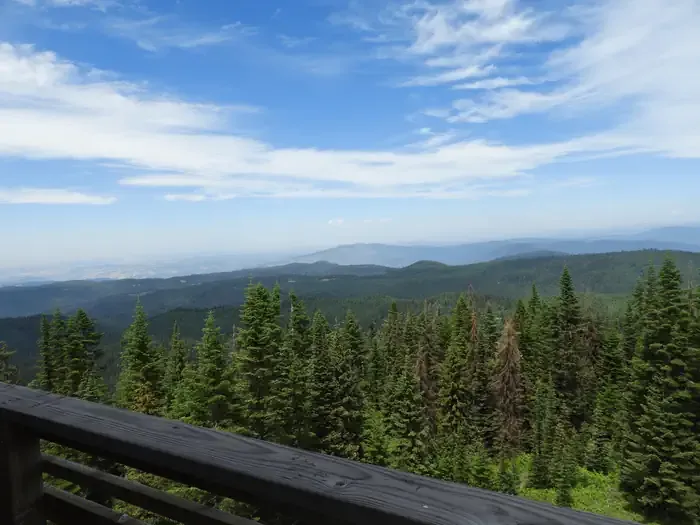
Black Bute Lookout Trail is a short, easy loop in Idaho's Gospel-Hump Wilderness, part of the Salmon River Ranger District of the Nez Perce-Clearwater National Forest. The Forest Service manages the land, and the trail starts and ends at about 6,672 feet, with a high point of 6,672 feet and a low of 6,253 feet along the way. The climb is back-loaded, with the steepest stretch at about 0.55 miles in, and the total gain is 399 feet for the 0.84-mile loop. Summer is the most comfortable time to go. Typical averages from a nearby weather station in Warren, Idaho, put July and August highs around 79°F with lows in the mid-30s, while winter highs stay in the mid-30s and lows drop to single digits. Lookout Butte Lookout sits just 0.1 mile away, and Johnson Saddle Trail is about 0.6 mile off. Farther out, Wind River offers canoeing about 2.3 miles away, and Hanover Mountain is about 2.2 miles away.
Local outfitters
- Black Bear RV Park43 mi away
Not on Roamze yet. Their page has how to reach them.
Conditions and forecast on Black Butte
Daily highs and lows, wind and the chance of precipitation at the summit and route start for the next 7 days, from the Open-Meteo model.
 Lookout Butte LookoutCampingPhoto: Recreation.gov (RIDB) / public domain0.1 mi
- Johnson Saddle TrailHiking0.6 mi
- Johnson Saddle CutoffHiking1.9 mi
- HANOVER MOUNTAINHiking2.2 mi
- Wind RiverCanoeing2.3 mi
- Johnson Saddle Stock TrailHiking2.8 mi
- Hanover Mountain TrailHiking2.9 mi
- Moores TrailHiking3.1 mi
Source: Roamze catalog (indexable pages within 10 miles, PostGIS distance)
- Johnson Saddle CutoffHiking · ~3 min drive
- Johnson Saddle Stock TrailHiking · ~5 min drive
- Lovell Gulch TrailHiking · ~7 min drive
- SHEEP MOUNTAIN CONNECTIONHiking · ~11 min drive
- HANOVER MOUNTAINHiking · ~4 min drive
- Moores TrailHiking · ~7 min drive
- Florence-Moores TrailHiking · ~10 min drive
- SQUARE MOUNTAIN SPURHiking · ~14 min drive
- Hanover Mountain TrailHiking · ~5 min drive
- Elk Butte TrailHiking · ~11 min drive
Best time to visit Black Bute Lookout Trail
Best months: June–August. Best months have typical highs of 55–85 °F, lows of 30 °F or warmer (32 °F where the station doesn't record snow), at most one snowy day and no more than 12 wet days.
Jan
35° / 7°
Feb
41° / 7°
Mar
46° / 17°
Apr
50° / 20°
May
59° / 27°
Jun
68° / 34°
Jul
79° / 37°
Aug
79° / 35°
Sep
69° / 30°
Oct
56° / 23°
Nov
41° / 16°
Dec
34° / 9°
Typical high / low (°F) and days with rain or snow, 1991–2020. Measured at Warren, ID, 18.2 mi away at 5,907 ft. The station sits about 800 ft lower than this place, so expect it a little cooler here. This station doesn't record snowfall. Source: NOAA NCEI U.S. Climate Normals 1991–2020.
Route details
- Distance
- 0.8 mi
- Climbing
- About 399 ft
- Summit
- 6,727 ft
- Difficulty
- Easy
- Time
- About 0.5 hours
Questions about this route
How long is the Black Bute Lookout Trail on Black Butte?
About 0.8 mi.
How much elevation gain is on the Black Bute Lookout Trail?
About 399 ft of climbing round trip.
How hard is the Black Bute Lookout Trail?
It is rated easy.
How long does the Black Bute Lookout Trail take?
About 0.5 hours round trip.
Map and trail data © OpenStreetMap contributors
