Halverson Bar/Lake
- Mar–Jun, Sep–Oct
- best months
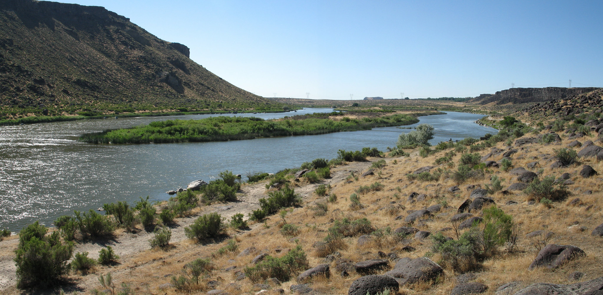
Named after brothers Al and Roy Halverson who once farmed property to the north, the Halverson Bar and Halverson Lake area is unique for its curving two-mile sandbar along the Snake River and its two shallow lakes nestled below the rimrock and tall sand dunes. The Halverson Bar and Halverson Lake area is located at the western end of the Morley Nelson Snake River Birds of Prey National Conservation Area (NCA). This 1,200 acre area is managed for non-motorized recreational activities. Motorized uses are not allowed in the area. The lakes were originally natural depressions that accumulated water seasonally and were sustained by small springs. The lakes have since been deepened by homesteaders and farmers. Today, most of the water in Halverson Lakes comes from irrigation run-off from the upland plateau. Decades ago the lakes were stocked with fish - blue gill, bass, and crappie - which are the primary catch today. Cliffs and sloping bluffs of basalt separate the shoreline and canyon bottom from the upland desert. Basaltic boulders, deposited by the flooding waters of Lake Bonneville 15,000 years ago, lie like giant-size melons on the sandy bar. The area includes a gravel parking area and several miles of hiking trails.
Local outfitters
- Lake Point Campground29 mi away
- Canyon Springs RV Resort29 mi away
Not on Roamze yet. Their page has how to reach them.
Best time to go · Mar–Jun, Sep–Oct
Best time to visit Halverson Bar/Lake
Best months: March–June and September–October. Best months have typical highs of 55–85 °F, lows of 30 °F or warmer (32 °F where the station doesn't record snow), at most one snowy day and no more than 12 wet days.
Jan
42° / 26°
9 wet
Feb
49° / 29°
7 wet
Mar
59° / 36°
8 wet
Apr
66° / 41°
8 wet
May
75° / 50°
8 wet
Jun
84° / 57°
5 wet
Jul
95° / 65°
2 wet
Aug
93° / 63°
2 wet
Sep
83° / 53°
3 wet
Oct
68° / 42°
5 wet
Nov
52° / 31°
7 wet
Dec
42° / 26°
9 wet
Typical high / low (°F) and days with rain or snow, 1991–2020. Measured at Swan Falls Ph, ID, 6.7 mi away at 2,325 ft. This station doesn't record snowfall. Source: NOAA NCEI U.S. Climate Normals 1991–2020.

Keep exploring — more waters worth the drive
SEE
Wilson Ponds
~30 min drive
Wilson Ponds is a 18-acre pond near Nampa, Idaho, at about 2,512 feet. It is managed by the state fish and wildlife agency.
SEE
Boise River
~45 min drive
Boise River is a river in Idaho.
SEE
Loggers Creek Pond
~45 min drive
Loggers Creek Pond is a 6-acre pond near Boise, Idaho, at about 2,712 feet.
SEE
Duff Pond
~49 min drive
Duff Pond is a 5-acre pond near Middleton, Idaho, at about 2,408 feet. It is managed by the state fish and wildlife agency.
SEE
Lucky Peak Lake
~56 min drive
Lucky Peak Lake is a 2,762-acre lake near Boise, Idaho, at about 3,126 feet.
SEE
Cove Arm Lake
~1h 7m drive
Cove Arm Lake is a 75-acre lake near Bruneau, Idaho, at about 2,457 feet. It is managed by the Bureau of Land Management.
SEE
Crane Falls Lake
~1h 8m drive
Crane Falls Lake is an 88-acre lake near Bruneau, Idaho, at about 2,457 feet. It is managed by the state fish and wildlife agency.
SEE
C. J. Strike Reservoir
~1h 13m drive
C. J. Strike Reservoir is a 148-acre reservoir near Bruneau, Idaho, at about 2,458 feet.
SEE
Lake Owyhee
~1h 16m drive
Lake Owyhee is a 11,120-acre lake near Jordan Valley, Oregon, at about 2,807 feet.
SEE
Glover Reservoir
~1h 19m drive
Glover Reservoir is a 6-acre reservoir near Jordan Valley, Oregon, at about 4,445 feet.


