
Mountain · 1 route
Gilpin Peak
13,691 ft · Colorado
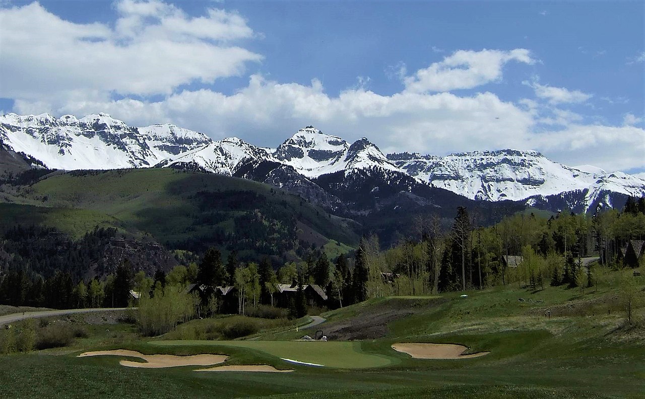
Photo: Greg Willis from Denver, CO, usa, CC BY-SA 2.0 (via Wikimedia Commons)
- Summit
- 13,691 ft
- Routes
- 1 way up
- Managed by
- Forest Service
Route up Gilpin Peak
About Gilpin Peak
Gilpin Peak is a summit of about 13,691 feet in Ouray County, Colorado, on the Ouray Ranger District of the Grand Mesa, Uncompahgre and Gunnison National Forests. The Forest Service manages the land, and the nearest town is Telluride, about 3.5 miles away. A summit route leads to the top. Cirque Mountain and Wrights Lake are both under a mile away. Mill Creek Basin Backcountry Camp sits about 1.1 miles off, and the climbing at Citradelica Rock is about 1.5 miles away.
Forecast on Gilpin Peak
Daily highs and lows, wind and the chance of precipitation at the summit and route start for the next 7 days, from the Open-Meteo model.
Questions about Gilpin Peak
How tall is Gilpin Peak?
13,691 ft (4,173 m).
How many routes go to the summit of Gilpin Peak?
One: Gilpin Peak.
Mountains nearby
 Mount Emma13,582 ft · Colorado1 route0.8 mi awayPhoto: Scott Brenner, CC BY 2.0 (via Wikimedia Commons)
 Mount Sneffels14,141 ft · Colorado1 route1.2 mi awayPhoto: Ken Lund from Reno, Nevada, USA, CC BY-SA 2.0 (via Wikimedia Commons)
 Dallas Peak13,785 ft · Colorado1 route1.7 mi awayPhoto: dana.m.wilson, CC BY 2.0 (via Wikimedia Commons)
 Cirque Mountain13,671 ft · Colorado1 route1.7 mi awayPhoto: Adam Baker, CC BY 2.0 (via Wikimedia Commons)
 Teakettle Mountain13,773 ft · Colorado1 route2.0 mi awayPhoto: dana.m.wilson, CC BY 2.5 (via Wikimedia Commons)
 Mount Ridgway13,475 ft · Colorado1 route2.9 mi awayPhoto: dana.m.wilson, CC BY 2.0 (via Wikimedia Commons)
Facts about this place
Where it is
- Ouray Ranger District · Ranger district
- Grand Mesa, Uncompahgre and Gunnison National Forests · National forest
- Nearest town
- Telluride, Colorado · 3.5 mi
- Managed by
- Forest Service
Source: USFS EDW boundaries; USGS PAD-US 4.1; USGS GNIS populated places
Conditions
Active alerts for Grand Mesa, Uncompahgre and Gunnison National Forests as of Oct 9, 2026:
2026-2027 GMUG National Forests Prescribed Pile Burn Plan
information · posted Oct 8, 2026
2026-2027 GMUG National Forests Prescribed Burn Plan
information · posted Oct 7, 2026
Gold Mountain Wildfire Roads and Trails Closure Order v 4.0
critical · posted Sep 14, 2026
TERMINATION OF ORDER - FIRE RESTRICTIONS
fire-restriction · posted Sep 2, 2026
Raggeds Wilderness Area Occupancy & Use
information · posted Aug 24, 2026
West Elk Wilderness Area Occupancy & Use
information · posted Aug 24, 2026
General Occupancy and Use on the Grand Mesa, Uncompahgre and Gunnison National Forests
information · posted Aug 24, 2026
information · posted Aug 24, 2026
Doctor Park (NFS Trail 424) Seasonal Closure
information · posted Aug 24, 2026
information · posted Aug 24, 2026
Source: USFS forest alerts
Nearby
 Cirque MountainHikingPhoto: Greg Willis from Denver, CO, usa, CC BY-SA 2.0 (via Wikimedia Commons)0.7 mi
 Wrights LakeHikingPhoto: Sale Family Memories, CC BY 2.0 (via Flickr)0.8 mi
- Mill Creek Basin Backcountry CampCamping1.1 mi
- Citradelica RockRock climbing1.5 mi
- Flowsnake RockRock climbing1.5 mi
- Wilderness Campsite 1Camping1.7 mi
- Canyon CreekCanoeing5.1 mi
 East Fork Dallas CreekCanoeingPhoto: Boyd Norton, Public domain (via Wikimedia Commons)6 mi
Source: Roamze catalog (indexable pages within 10 miles, PostGIS distance)
Is Gilpin Peak open right now?
Closure in the area
There's a closure order in Grand Mesa, Uncompahgre and Gunnison National Forests. It doesn't name Gilpin Peak, so check the source for the area it covers (2 listed).
Gold Mountain Wildfire Roads and Trails Closure Order v 4.0
Agency closure covering Grand Mesa, Uncompahgre and Gunnison National Forests · USFS · Grand Mesa, Uncompahgre and Gunnison National Forests
Ophir Pass Road Closure
Agency closure covering Grand Mesa, Uncompahgre and Gunnison National Forests · USFS · Grand Mesa, Uncompahgre and Gunnison National Forests
TERMINATION OF ORDER - FIRE RESTRICTIONS
Agency alert covering Grand Mesa, Uncompahgre and Gunnison National Forests · USFS · Grand Mesa, Uncompahgre and Gunnison National Forests
Dallas Area Closure order
Agency alert covering Grand Mesa, Uncompahgre and Gunnison National Forests · USFS · Grand Mesa, Uncompahgre and Gunnison National Forests
Island Lake Road Closure
Agency alert covering Grand Mesa, Uncompahgre and Gunnison National Forests · USFS · Grand Mesa, Uncompahgre and Gunnison National Forests
As of · Source: USFS · Grand Mesa, Uncompahgre and Gunnison National Forests. Agencies don't list every closure — check before you go.
