Castle Rock
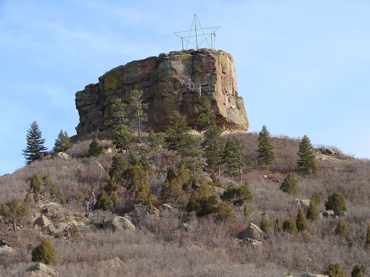 Photo: Jeff Albright, CC BY-SA 3.0 (via Wikimedia Commons)
- 6,589 ft
- summit
- 1
- way up
- County Land
- managed by
- Apr–Jun, Aug–Oct
- best months
Castle Rock is a summit of 6,589 feet in Colorado, sitting within Rock Park on county land about 0.2 miles from the town of Castle Rock. Its elevation makes it a natural anchor for the trails that start close by. For comfortable weather, aim for late spring or early fall. Typical averages from a nearby weather station in Castle Rock show May highs around 68°F and September highs around 77°F, with lows in the 40s. That station sits a few hundred feet lower than the summit, so temperatures up top run a little cooler. The John Emerson Summit Trail passes just 0.1 mile away, and the Memmen Ridge Open Space Trail and Purple Loop Trail are both within about a mile and a half. Climbers can head to Corona Crag, roughly 3 miles off.
Conditions and forecast
Daily highs and lows, wind and the chance of precipitation at the summit and route start for the next 7 days, from the Open-Meteo model.
- Summit elevation
- 6,589 ft
- Land manager
- County Land
Elevation from USGS 3D Elevation Program terrain data (about 10 m resolution).
Map © Mapbox © OpenStreetMap contributors Questions about Castle Rock
How tall is Castle Rock?
6,589 ft (2,008 m).
How many routes go to the summit of Castle Rock?
One: John Emerson Summit Trail.
 Carpenter Peak7,169 ft · Colorado1 route13 mi awayPhoto: MAD Hippies Life, CC BY-SA 2.0 (via Wikimedia Commons)
- Bear Mountain7,735 ft · Colorado1 route15 mi away
 Devils Head9,723 ft · Colorado2 routes16 mi awayPhoto: Jeff Albright, CC BY-SA 3.0 (via Wikimedia Commons)
- Spruce Mountain7,616 ft · Colorado1 route16 mi away
- Goat Mountain7,788 ft · Colorado1 route17 mi away
- Sundance Mountain8,256 ft · Colorado2 routes18 mi away
- John Emerson Summit TrailHiking0.1 mi
- Memmen Ridge Open Space TrailHiking0.9 mi
- Purple Loop TrailHiking1.3 mi
- Corona CragRock climbing3.1 mi
- Pandemic CavesRock climbing3.1 mi
- The Pinery Rv LotCamping7.4 mi
 Yogi Bear's Jellystone Park LarkspurCampingPhoto: Jacob Montgomery, CC BY-SA 3.0 (via Wikimedia Commons)8.3 mi
 Cherry CreekCanoeingPhoto: Tim Kiser (w:User:Malepheasant), CC BY-SA 2.5 (via Wikimedia Commons)9.2 mi
Source: Roamze catalog (indexable pages within 10 miles, PostGIS distance)
 Dawson ButteSummit · ~12 min drivePhoto: Jeffrey Beall, CC BY 4.0 (via Wikimedia Commons)
- Carpenter PeakSummit · ~22 min drivePhoto: MAD Hippies Life, CC BY-SA 2.0 (via Wikimedia Commons)
- Devils HeadSummit · ~27 min drivePhoto: Jeff Albright, CC BY-SA 3.0 (via Wikimedia Commons)
 Elephant RockSummit · ~31 min drivePhoto: Oclupaca, CC0 (via Wikimedia Commons)
 Long Scraggy PeakSummit · ~32 min drivePhoto: Jeffrey Beall, CC BY 4.0 (via Wikimedia Commons)
 Mount HermanSummit · ~36 min drivePhoto: Jeffrey Beall, CC BY 4.0 (via Wikimedia Commons)
 Cathedral SpiresSummit · ~37 min drivePhoto: Unknown authorUnknown author, Public domain (via Wikimedia Commons)
 Mount CarbonSummit · ~41 min drivePhoto: Xnatedawgx, CC BY-SA 3.0 (via Wikimedia Commons)
 Green MountainSummit · ~42 min drivePhoto: Thomson200, CC0 (via Wikimedia Commons)
 Mount LindoSummit · ~42 min drivePhoto: Paradoxsociety, CC BY-SA 4.0 (via Wikimedia Commons)
Best time to visit Castle Rock
Best months: April–June and August–October. Best months have typical highs of 55–85 °F, lows of 30 °F or warmer (32 °F where the station doesn't record snow), at most one snowy day and no more than 12 wet days.
Jan
46° / 18°
4 wet
Feb
47° / 20°
5 wet
Mar
54° / 27°
5 wet
Apr
59° / 33°
6 wet
May
68° / 42°
8 wet
Jun
80° / 50°
8 wet
Jul
86° / 56°
9 wet
Aug
84° / 55°
9 wet
Sep
77° / 47°
6 wet
Oct
65° / 35°
4 wet
Nov
54° / 26°
4 wet
Dec
46° / 18°
5 wet
Typical high / low (°F) and days with rain or snow, 1991–2020. Measured at Castle Rock, CO, 3.5 mi away at 6,185 ft. This station doesn't record snowfall. Source: NOAA NCEI U.S. Climate Normals 1991–2020.


