Old D&RGW Abandoned Rail Trail
- May–Sep
- best months
Is Old D&RGW Abandoned Rail Trail open right now?
Alert in the area
The National Park Service lists an alert for Curecanti National Recreation Area.
Toxic Algae May Be Present In Blue Mesa Reservoir
Park alert covering Curecanti National Recreation Area · NPS · Curecanti National Recreation Area
As of · Source: NPS · Curecanti National Recreation Area. Agencies don't list every closure — check before you go.
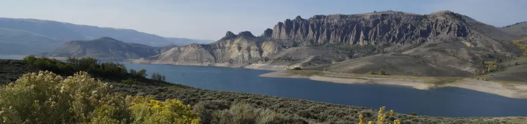
Old D&RGW Abandoned Rail Trail is a paddling route in Colorado's Curecanti National Recreation Area, managed by the Bureau of Land Management's Gunnison Field Office. It lies within the national recreation area and on BLM land, and it sits about 0.2 miles from Lake Fork Arm, the nearest campground. For comfortable paddling weather, summer is the clear choice. Typical averages from the Blue Mesa Lake weather station, about 6.5 miles away, show July highs around 83°F with lows near 46°F, and June and August are close behind. Winter is harsh, with January highs around 25°F and lows near -1°F. Several other destinations are close by. The Lake City Branch Abandoned Railway is about 2.8 miles away, and the Denver & Rio Grande Western Abandoned Railroad is about 3.4 miles off. On foot, Dillon Pinnacles Trail is about 3.1 miles away, and Lake Fork Gunnison River Trail is about 3.5 miles away.
Local outfitters
- Cedar Creek RV Park and Lodging32 mi away
- SUP Marble45 mi away
Not on Roamze yet. Their page has how to reach them.
- Lake Fork ArmCamping0.2 mi
- Lake City Branch Abandoned RailwayCanoeing2.8 mi
 Dillon Pinnacles TrailHikingPhoto: AndreyZharkikh, CC BY 2.0 (via Flickr)3.1 mi
- Denver & Rio Grande Western Abandoned RailroadCanoeing3.4 mi
- Lake Fork Gunnison River TrailHiking3.5 mi
 Lake Fork CampgroundCampingPhoto: Recreation.gov (RIDB) / public domain3.5 mi
- Red Creek CampgroundCamping4.3 mi
 Pine Creek TrailHikingPhoto: AndreyZharkikh, CC BY 2.0 (via Flickr)5 mi
Source: Roamze catalog (indexable pages within 10 miles, PostGIS distance)
 Blue CreekCanoeing · ~12 min drivePhoto: Jeffrey Beall, CC BY 4.0 (via Wikimedia Commons)
- Sapinero BeachBoat launch · ~4 min drive
- Stevens Creek CampgroundTubing · ~18 min drive
- One MileFloat trip · ~60 min drive
 Cebolla CreekCanoeing · ~38 min drivePhoto: Jeffrey Beall, CC BY 4.0 (via Wikimedia Commons)
- Lake Fork Boat LaunchBoat launch · ~5 min drive
 Smith ForkCanoeing · ~49 min drivePhoto: Jeffrey Beall, CC BY 3.0 (via Wikimedia Commons)
- Dillon PinnaclesBoat launch · ~5 min drive
 Cochetopa CreekCanoeing · ~51 min drivePhoto: Ken Lund from Reno, Nevada, USA, CC BY-SA 2.0 (via Wikimedia Commons)
- Lake ForkBoat launch · ~5 min drive
Best time to visit Old D&RGW Abandoned Rail Trail
Best months: May–September. Best months have typical highs of 55–85 °F, lows of 30 °F or warmer (32 °F where the station doesn't record snow), at most one snowy day and no more than 12 wet days.
Jan
25° / -1°
8 wet
Feb
30° / 3°
6 wet
Mar
43° / 15°
5 wet
Apr
56° / 24°
5 wet
May
66° / 32°
5 wet
Jun
77° / 39°
4 wet
Jul
83° / 46°
7 wet
Aug
80° / 45°
8 wet
Sep
73° / 37°
7 wet
Oct
60° / 27°
5 wet
Nov
44° / 15°
5 wet
Dec
29° / 3°
7 wet
Typical high / low (°F) and days with rain or snow, 1991–2020. Measured at Blue Mesa Lake, CO, 6.5 mi away at 7,568 ft. This station doesn't record snowfall. Source: NOAA NCEI U.S. Climate Normals 1991–2020.
Map and trail data © OpenStreetMap contributors
