May Queen
Campground
Campground · < 0.1 mi from the trail
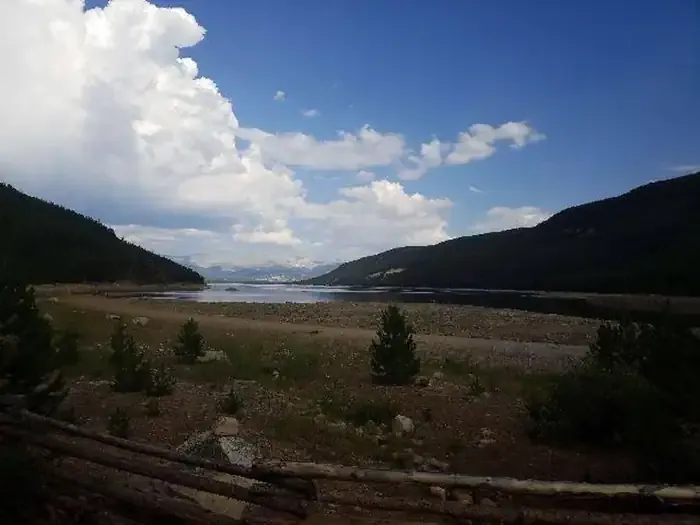 Photo: Recreation.gov (RIDB) / public domain
Closure in the area
There's a closure order in Leadville Ranger District. It doesn't name May Queen, so check the source for the area it covers.
Willow Fire Area Closure
Agency closure covering Leadville Ranger District · Order 02-12-01-26-39 · USFS · Leadville Ranger District
FSR 286, Radical Hill, is closed due to washouts and unsafe conditions
Agency alert covering Pike and San Isabel National Forests · USFS · Pike and San Isabel National Forests
Interlaken Hotel and Annex Area closure
Agency alert covering Leadville Ranger District · Order 02-12-01-26-19 · USFS · Leadville Ranger District
Interlaken Hotel Tree Hazards
Agency alert covering Pike and San Isabel National Forests · USFS · Pike and San Isabel National Forests
Sharpe Fire Update
Agency alert covering Pike and San Isabel National Forests · USFS · Pike and San Isabel National Forests
As of · Source: USFS · Leadville Ranger District. Agencies don't list every closure — check before you go.
May Queen Campground is located at the far western end of Turquoise Lake in a shaded lodgepole pine forest. Conveniently perched near the Charles Boustead Memorial Tunnel, May Queen offers easy access to boating, fishing and hiking. Incredible views of the Holy Cross and Mount Massive Wildernesses can be seen from the area, and visitors are likely to see native wildlife like chipmunks, beavers and porcupines. The Charles Boustead Memorial Tunnel is a 5.5-mile tunnel that transports water from the Fryingpan and Roaring Fork River Basins through the Continental Divide to the Arkansas River Basin by emptying water into Turquoise Lake.
May Queen
Campground
La Mina Tacos Y Mariscos
Restaurant
 If it rainsCraig Talbert, CC BY 3.0 · Wikimedia Commons
Places © OpenStreetMap contributors · Photos: Craig Talbert, CC BY 3.0 (commons)
More in LeadvilleNot on Roamze yet. Their page has how to reach them.
 BUSK CREEKHikingPhoto: Altitude10k, CC BY 2.0 (via Flickr)0.3 miBusk Creek TrailHikingPhoto: Altitude10k, CC BY 2.0 (via Flickr)0.5 mi
 Tiger CliffRock climbingPhoto: foto3116, CC BY 2.0 (via Flickr)3.2 miMain WallRock climbingPhoto: foto3116, CC BY 2.0 (via Flickr)3.2 mi
Source: Roamze catalog (indexable pages within 10 miles, PostGIS distance)
Also worth it near here
BUSK CREEKHiking · Next doorPhoto: Altitude10k, CC BY 2.0 (via Flickr) Galena MountainSummit · ~4 min drivePhoto: Clyde Charles Brown, CC BY-SA 4.0 (via Wikimedia Commons)Main WallRock climbing · ~6 min drivePhoto: foto3116, CC BY 2.0 (via Flickr)
 Ddh Headgates RoadCross-country skiing · ~6 min drivePhoto: USFWS Mountain-Prairie, CC BY 2.0 (via Wikimedia Commons)
Best months: June–August. Best months have typical highs of 55–85 °F, lows of 30 °F or warmer (32 °F where the station doesn't record snow), at most one snowy day and no more than 12 wet days.
Jan
31° / 3°
8 wet
Feb
33° / 3°
8 wet
Mar
39° / 9°
8 wet
Apr
44° / 18°
8 wet
May
55° / 27°
9 wet
Jun
68° / 34°
9 wet
Jul
73° / 39°
12 wet
Aug
70° / 38°
12 wet
Sep
62° / 31°
8 wet
Oct
51° / 23°
6 wet
Nov
39° / 14°
7 wet
Dec
31° / 6°
7 wet
Typical high / low (°F) and days with rain or snow, 1991–2020. Measured at Sugarloaf Rsvr, CO, 3.8 mi away at 9,738 ft. This station doesn't record snowfall. Source: NOAA NCEI U.S. Climate Normals 1991–2020.
May Queen
28 sites for RV and tent camping
