Cold Springs Campground
Campground
Campground · 0.5 mi from the trail
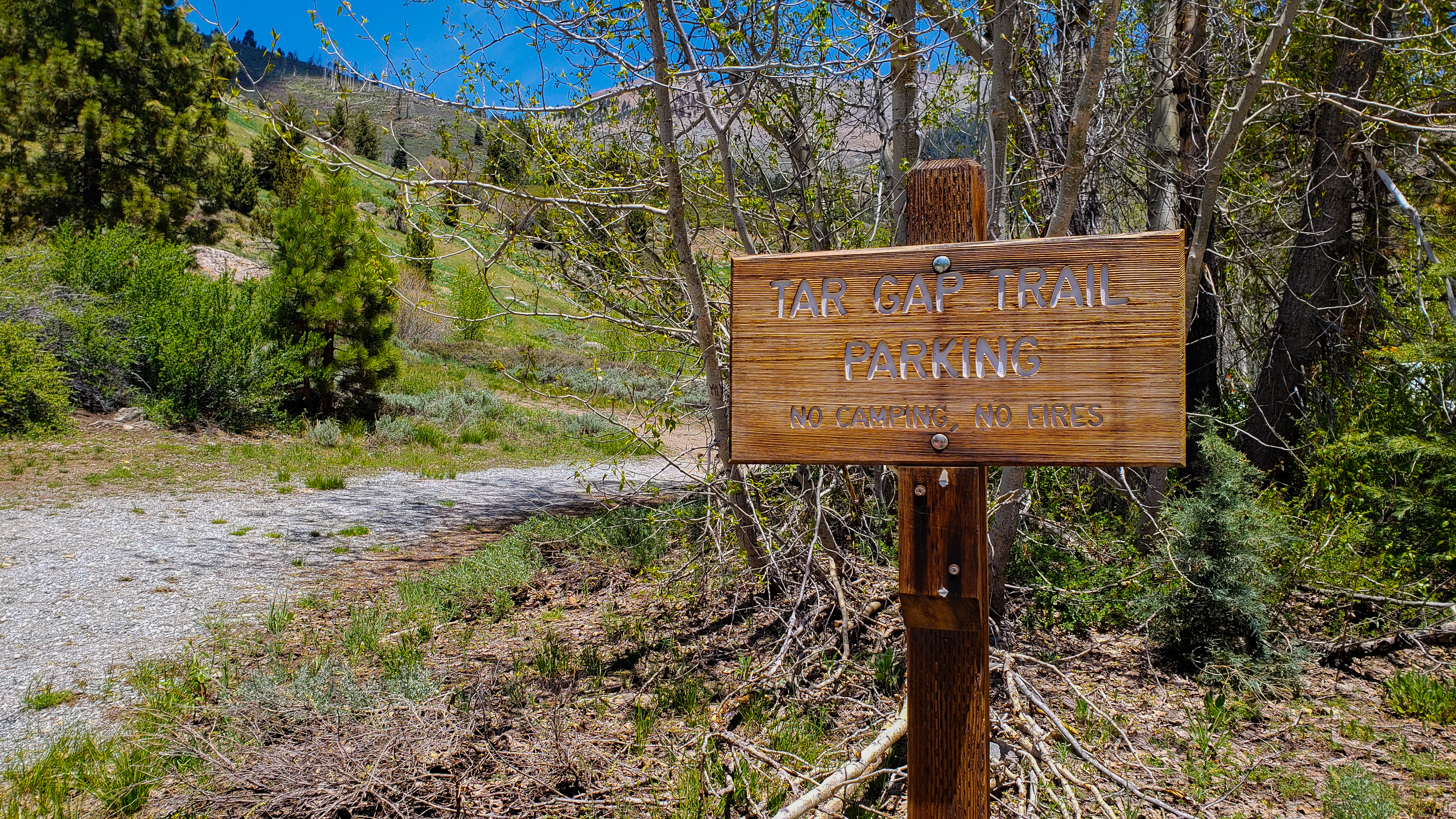 Photo: NPS / Scott Andrew Taylor
No closures listed
The National Park Service lists no closures for Sequoia National Park.
As of · Source: NPS · Sequoia National Park. Agencies don't list every closure — check before you go.
Tar Gap Trail Parking is a National Park Service overflow parking area in Sequoia National Park, California. It serves as an alternative when other trailhead lots are full, and it sits among the park's network of trailheads, close to Cold Springs Nature Trail - Western Trailhead and Cold Spring Campground. Spring and early summer are the time to watch for marmots, which can damage vehicles. That makes the parking a practical choice when the main lots are full, but it also means drivers should take care with their cars from late spring through early summer. Late spring and early fall are the most comfortable times to visit. Typical averages from a nearby weather station show May highs around 58°F with lows near 33°F, and September highs near 70°F with lows around 39°F. That station sits about 850 feet lower than this parking, so temperatures here run cooler. Within a mile are Cold Springs Nature Trail - Western Trailhead, Cold Spring Campground and Timber Gap. The Farewell Gap-Franklin Lakes Trailhead is just over 0.7 miles away.
Cold Springs Campground
Campground
 If it rainsDavid Fulmer, CC BY 2.0 · Wikimedia Commons
Giant Forest Museum
Museum
Places © OpenStreetMap contributors · Photos: David Fulmer, CC BY 2.0 (commons)
More in Silver CityNot on Roamze yet. Their page has how to reach them.
Best months: June–October. Best months have typical highs of 55–85 °F, lows of 30 °F or warmer (32 °F where the station doesn't record snow), at most one snowy day and no more than 12 wet days.
Jan
39° / 17°
9 wet · 8 snow
Feb
41° / 18°
10 wet · 8 snow
Mar
45° / 22°
10 wet · 8 snow
Apr
50° / 26°
8 wet · 5 snow
May
58° / 33°
5 wet · 2 snow
Jun
68° / 40°
3 wet
Jul
76° / 46°
2 wet
Aug
76° / 44°
2 wet
Sep
70° / 39°
2 wet
Oct
59° / 31°
4 wet · 1 snow
Nov
47° / 23°
6 wet · 4 snow
Dec
37° / 17°
8 wet · 6 snow
Typical high / low (°F) and days with rain or snow, 1991–2020. Measured at Lodgepole, CA, 12.5 mi away at 6,735 ft. The station sits about 900 ft lower than this place, so expect it a little cooler here. Source: NOAA NCEI U.S. Climate Normals 1991–2020.
HIKE
Cold Springs Nature Trail - Western Trailhead
Next door
This trailhead is located within Cold Springs Campground, look for a wooden trailhead sign between sites 6 and 7. Cold Springs Nature Trail is 2.0 miles round-trip (3.2 kilometer) at an easy incline. It travels through meadows and aspen groves to the site of the former…
 Photo: J Doll, CC BY 3.0 (via Wikimedia Commons)
Timber Gap
Next door
2.25-mile out-and-back trail in California with 1,191 ft gain and 9,491 ft max elevation.
 Photo: troy_williams, CC BY 2.0 (via Flickr)
Blackrock Pass - Pinto Lake
~5 min drive
6.16-mile out-and-back trail in California's National Park Service area with 4,547 ft elevation gain.
HIKE
Paradise Ridge Trailhead
~6 min drive
This 5.5 mile loop (8.85 kilometers) is a moderate climb, with frequent ups and downs. Starting with views at Panoramic Point, the trail visits a fire lookout, dense forest, and logged and fire-scarred areas. This trailhead orientation panel shows a map and images of the…
 Photo: Chris English, CC BY-SA 3.0 (via Wikimedia Commons)
Cold Spring CG
Next door
Cold Spring CG is a 0.44-mile out-and-back trail in California with 122 ft of elevation gain.
HIKE
Farewell Gap-Franklin Lakes Trailhead
~1 min drive
This trailhead orientation panel shows a map and images of the area around Farewell Gap Trail and Franklin Lakes Trail. Farewell Gap Trail and Franklin Lakes Trail share the same route for the first 2.8 miles. From there, Farewell Gap Trail travels to the right for 2.7 miles…
 Photo: HikingMike, CC BY 2.0 (via Flickr)
Paradise Ridge-Redwood Mdw
~7 min drive
5.84-mile out-and-back trail in California with 3,183 ft elevation gain.
 Photo: J Doll, CC BY 3.0 (via Wikimedia Commons)
Farewell/Franklin
~3 min drive
0.82-mile out-and-back trail in California with 97 ft gain.
 Photo: J Doll, CC BY 3.0 (via Wikimedia Commons)
Timber Gap Cliff Creek
~2 min drive
2.95-mile out-and-back trail in California with 2,418 ft elevation gain.
HIKE
Atwell-Hockett
~10 min drive
10.48-mile out-and-back trail in California with 2,857 ft elevation gain.


