Cucamonga Peak - Non Wildernes
 Photo: GSEC, CC BY 2.0 (via Flickr)
- 1.5 mi
- round trip
- 461 ft
- climb
- 6,379 ft
- high point
- Out and back
- route
- Apr–Oct
- best months
Is Cucamonga Peak - Non Wildernes open right now?
Alert in the area
The Forest Service lists 4 alerts for San Bernardino National Forest.
Safety Alert - Falling Rocks at Bonita Falls
Agency alert covering San Bernardino National Forest · USFS · San Bernardino National Forest
Upper Big Falls Area Closure
Agency alert covering Front Country Ranger District · Order 05-12-53-26-03 · USFS · Front Country Ranger District
Fire Restrictions
Agency alert covering San Bernardino National Forest · Order 05-12-00-26-05 · USFS · San Bernardino National Forest
Applewhite Picnic Area Closure
Agency alert covering Front Country Ranger District · Order 05-12-53-26-01 · USFS · Front Country Ranger District
As of · Source: USFS · San Bernardino National Forest. Agencies don't list every closure — check before you go.
Cucamonga Peak is an easy out-and-back hike of about 1.5 miles in the Front Country Ranger District of San Bernardino National Forest, managed by the Forest Service. The trail is accessible and has a natural surface, and it rises about 460 feet from a low point of roughly 5,900 feet to a high of about 6,400 feet. Spring and fall are the most comfortable times to go. Typical averages from a nearby weather station in Wrightwood show May highs around 69°F and October highs around 64°F, while winter highs sit in the upper 40s. The Middlefork - Wilderness and Stonehouse - Stonehouse Cut-Of hikes both lie about 2.3 miles away. Icehouse Canyon, a climbing area, and Lytle Creek - Cajon Pass Recreation Area, a fishing spot, are each about 4.3 miles off.
 Middlefork - WildernessHikingPhoto: joedecruyenaere on Flickr, CC BY-SA 2.0 (via Wikimedia Commons)2.3 mi
- Stonehouse - Stonehouse Cut-OfHikingPhoto: joedecruyenaere on Flickr, CC BY-SA 2.0 (via Wikimedia Commons)2.3 mi
- Icehouse CanyonRock climbing4.3 mi
- Lytle Creek - Cajon Pass Recreation AreaRiver fishing4.3 mi
- Mount Baldy RoadRock climbing5.2 mi
- Manker FlatCamping5.4 mi
- Cajon WashCanoeing9.6 mi
- LupineCamping9.9 mi
Source: Roamze catalog (indexable pages within 10 miles, PostGIS distance)
- Middlefork - WildernessHiking · ~4 min drivePhoto: joedecruyenaere on Flickr, CC BY-SA 2.0 (via Wikimedia Commons)
- Stonehouse - Stonehouse Cut-OfHiking · ~4 min drivePhoto: joedecruyenaere on Flickr, CC BY-SA 2.0 (via Wikimedia Commons)
 Three Ts TrailHiking · ~8 min drivePhoto: inkknife_2000 (7.5 million views +), CC BY-SA 2.0 (via Wikimedia Commons)
 Cucamonga Pk- Icehouse SaddleHiking · ~5 min drivePhoto: Mitch from Costa Mesa, CA, USA, CC BY-SA 2.0 (via Wikimedia Commons)
- BIGHORN PEAK TRAILHiking · ~5 min drivePhoto: Mitch from Costa Mesa, CA, USA, CC BY-SA 2.0 (via Wikimedia Commons)
 Devils Backbone TrailHiking · ~8 min drivePhoto: inkknife_2000 (7.5 million views +), CC BY-SA 2.0 (via Wikimedia Commons)
 Icehouse Canyon TrailHiking · ~6 min drivePhoto: simonov, CC BY-SA 2.0 (via Flickr)
 Telegraph Peak TrailHiking · ~6 min drivePhoto: Moo.The.Cow, CC BY 2.0 (via Flickr)
 Baldy Bowl TrailHiking · ~11 min drivePhoto: feverblue, CC BY-SA 2.0 (via Flickr)
- Three T'sHiking · ~7 min drivePhoto: inkknife_2000 (7.5 million views +), CC BY-SA 2.0 (via Wikimedia Commons)
Also worth it near here
- Joe Elliot Yellow Post SitesCamping · Next door
- Cucamonga Peak - Non WildernesMountain biking · Next doorPhoto: Mitch from Costa Mesa, CA, USA, CC BY-SA 2.0 (via Wikimedia Commons)
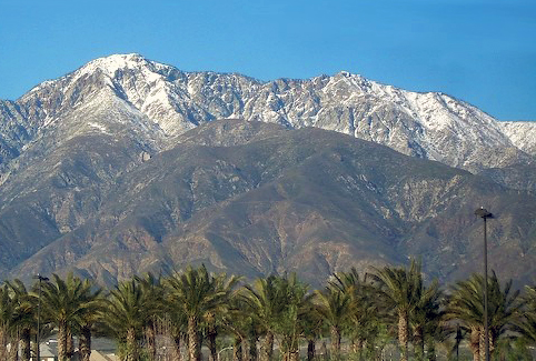 Cucamonga PeakSummit · ~3 min drivePhoto: Cliff Hutson; later cropping and color editing by Daniel Case., CC BY 2.0 (via Wikimedia Commons)
 Bonita FallsWaterfall · ~5 min drivePhoto: San Bernardino Nat'l Forest, Public domain (via Wikimedia Commons)
Best time to visit Cucamonga Peak - Non Wildernes
Best months: April–October. Best months have typical highs of 55–85 °F, lows of 30 °F or warmer (32 °F where the station doesn't record snow), at most one snowy day and no more than 12 wet days.
Jan
48° / 26°
5 wet
Feb
48° / 25°
8 wet
Mar
54° / 29°
6 wet
Apr
60° / 32°
4 wet
May
69° / 39°
2 wet
Jun
78° / 44°
1 wet
Jul
83° / 53°
2 wet
Aug
82° / 51°
2 wet
Sep
75° / 46°
2 wet
Oct
64° / 37°
3 wet
Nov
55° / 29°
4 wet
Dec
47° / 25°
5 wet
Typical high / low (°F) and days with rain or snow, 1991–2020. Measured at Wrightwood, CA, 10.9 mi away at 6,000 ft. This station doesn't record snowfall. Source: NOAA NCEI U.S. Climate Normals 1991–2020.
