The Tepees North Pullout
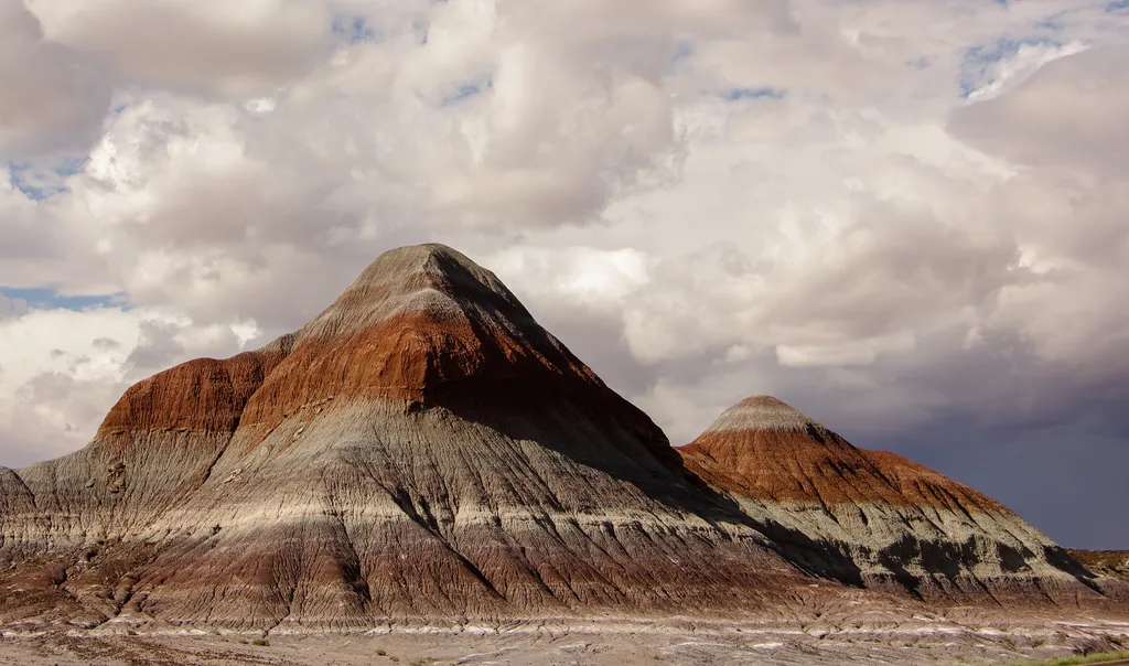 Photo: NPS / public domain
- Mar–May, Sep–Oct
- best months
Is The Tepees North Pullout open right now?
Closure in the area
There's a closure order in Petrified Forest National Park. It doesn't name The Tepees North Pullout, so check the source for the area it covers.
Painted Desert Visitor Center Closed for Construction
Park closure covering Petrified Forest National Park · NPS · Petrified Forest National Park
As of · Source: NPS · Petrified Forest National Park. Agencies don't list every closure — check before you go.
The Tepees North Pullout is a stop in Petrified Forest National Park in eastern Arizona, managed by the National Park Service. The area is named for the conical hills of banded mudstone that were thought to resemble tepees, or tipis. Some Navajos have pointed out one of the hills that looks like a male hogan. Spring and fall are the most comfortable times to visit. Typical averages from a nearby weather station show April highs around 68°F and October highs around 70°F, while July averages about 92°F and January lows drop to about 22°F. A fee is charged for park activities. The Tepees South Pullout is about 0.1 mile away. The Historic Blue Forest Trail and Blue Mesa Trail are each about a mile off, and Puerco Pueblo is roughly 2.4 miles away.
Local outfitters
- OK RV Park21 mi away
Not on Roamze yet. Their page has how to reach them.
Best time to go · Mar–May, Sep–Oct
Best time to visit The Tepees North Pullout
Best months: March–May and September–October. Best months have typical highs of 55–85 °F, lows of 30 °F or warmer (32 °F where the station doesn't record snow), at most one snowy day and no more than 12 wet days.
Jan
48° / 22°
4 wet
Feb
52° / 25°
4 wet
Mar
61° / 30°
4 wet
Apr
68° / 35°
3 wet
May
78° / 44°
3 wet
Jun
89° / 53°
3 wet
Jul
92° / 60°
7 wet
Aug
88° / 58°
9 wet
Sep
82° / 51°
6 wet
Oct
70° / 40°
5 wet
Nov
58° / 28°
4 wet
Dec
46° / 22°
5 wet
Typical high / low (°F) and days with rain or snow, 1991–2020. Measured at Painted Desert Np, AZ, 8.5 mi away at 5,760 ft. Source: NOAA NCEI U.S. Climate Normals 1991–2020.
Keep exploring — more trails worth the drive
 Photo: Fredlyfish4, CC BY-SA 4.0 (via Wikimedia Commons)
The Tepees South Pullout
Next door
The Tepees is a area of the park named for the conical hills with banded mudstones that were thought to resemble tepees—or tipis as some people spell it. Tipis are not part of the culture in this region, but some Navajos have pointed out one of the hills that resembles a male…
 Photo: Navin75, CC BY-SA 2.0 (via Flickr)
Historic Blue Forest Trail
~2 min drive
2.56-mile out-and-back trail in Arizona with 332 ft elevation gain.
 Photo: dconvertini, CC BY-SA 2.0 (via Flickr)
Blue Mesa Trail
~2 min drive
Length: 1 mile (1.6 km) loop Trailhead: Blue Mesa sun shelter Descending from the mesa, this alternately paved and gravel trail loop offers the unique experience of hiking among badland hills of bluish bentonite clay as well as petrified wood. Numerous plant and animal fossils…
 Photo: Alexander Hatley, CC BY 2.0 (via Flickr)
Jasper Forest Trail
~7 min drive
2.04-mile out-and-back trail in Arizona with 137 ft elevation gain.
 Photo: dconvertini, CC BY-SA 2.0 (via Flickr)
Puerco Pueblo
~4 min drive
Puerco Pueblo is located at mile marker 11 (11 miles from the north entrance of Petrified Forest National Park), the only ancestral Puebloan village that is easily accessible to the public. The 1/3 of a mile loop trail meanders through the ancient site, complete with exhibits…
 Photo: Šarūnas Burdulis from USA, CC BY-SA 2.0 (via Wikimedia Commons)
Crystal Forest Trail
~10 min drive
Easy 0.82-mile out-and-back forest walk in Arizona.
HIKE
Agate Bridge
~6 min drive
Agate Bridge, original called Natural Bridge, is a partially exposed petrified log spanning a gully at Agate Mesa, forming a “bridge”. This landmark has long been one of the most popular attractions in Petrified Forest since the beginning and in the early history of the park m…
 Photo: Navin75, CC BY-SA 2.0 (via Flickr)
Tawa Trail
~14 min drive
2.08-mile out-and-back hike in Arizona with 140 ft elevation gain
 Photo: Alexander Hatley, CC BY 2.0 (via Flickr)
Crystal Forest Trail
~10 min drive
Length: 0.75 mile (1.2 km) loopTrailhead: Crystal Forest parking areaNamed for the presence of beautiful crystals that can be found in the petrified logs, this trail offers one of the best opportunities to experience the petrified wood deposits. Please leave the petrified wood…
 Photo: Alexander Hatley, CC BY 2.0 (via Flickr)
Giant Logs Trail
~18 min drive
Easy out-and-back walk through petrified wood in Arizona.


