Agate Bridge
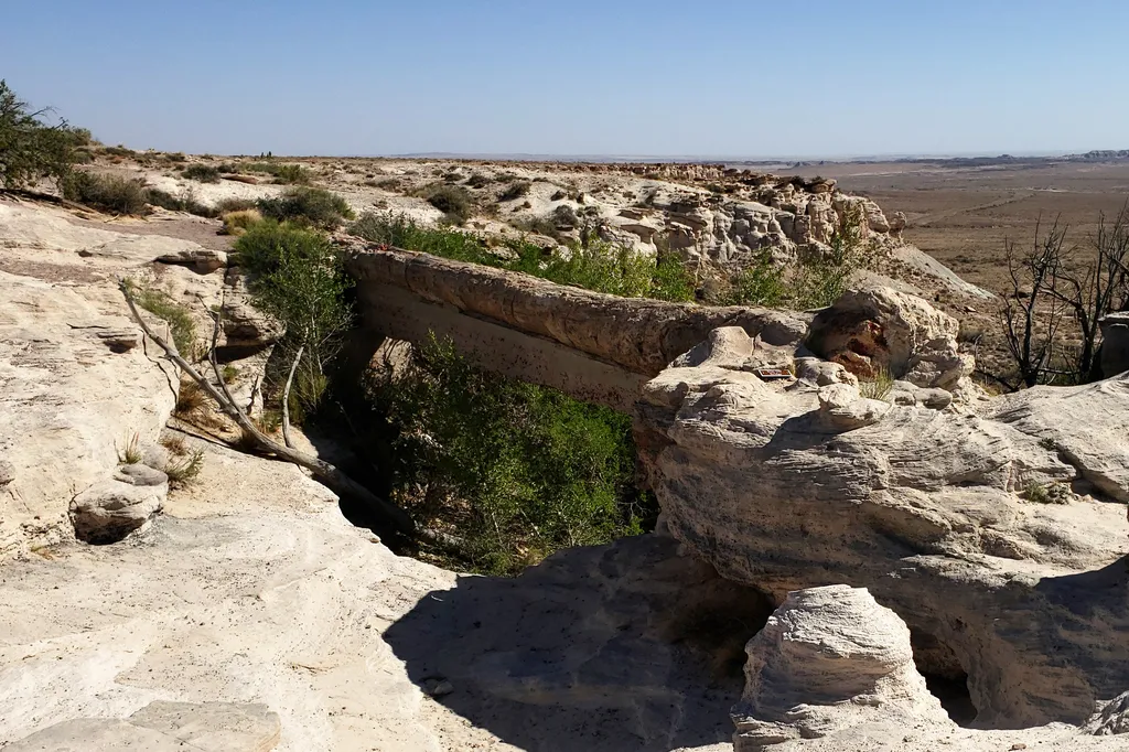 Photo: NPS / public domain
- Apr–May, Sep–Oct
- best months
Is Agate Bridge open right now?
Closure in the area
There's a closure order in Petrified Forest National Park. It doesn't name Agate Bridge, so check the source for the area it covers.
Painted Desert Visitor Center Closed for Construction
Park closure covering Petrified Forest National Park · NPS · Petrified Forest National Park
As of · Source: NPS · Petrified Forest National Park. Agencies don't list every closure — check before you go.
Agate Bridge, original called Natural Bridge, is a partially exposed petrified log spanning a gully at Agate Mesa, forming a “bridge”. This landmark has long been one of the most popular attractions in Petrified Forest since the beginning and in the early history of the park many visitors had their picture taken while standing on the “bridge”. Fear of the collapse of this landmark by the railroad—it was a major attraction—led to masonry pillars being constructed underneath is April of 1903, later followed by concrete in 1911. These were replaced by concrete beam in 1917 at the cost of $1700, paid for by the government and installed by the railroad. The log is about 100’ in length and 4’ in diameter at its base. It spans 40’ across the chasm and is 16’ above the canyon floor. In the late 1800s the paleobotanist Lester Ward proclaimed Agate Bridge to be the “most noted single petrified log in the world.”
Local outfitters
- OK RV Park20 mi away
Not on Roamze yet. Their page has how to reach them.
Best time to go · Apr–May, Sep–Oct
Best time to visit Agate Bridge
Best months: April–May and September–October. Best months have typical highs of 55–85 °F, lows of 30 °F or warmer (32 °F where the station doesn't record snow), at most one snowy day and no more than 12 wet days.
Jan
50° / 21°
5 wet
Feb
56° / 24°
5 wet
Mar
65° / 30°
5 wet
Apr
72° / 36°
4 wet
May
81° / 43°
3 wet
Jun
91° / 53°
3 wet
Jul
93° / 60°
8 wet
Aug
90° / 59°
9 wet
Sep
85° / 52°
6 wet
Oct
74° / 39°
5 wet
Nov
61° / 28°
4 wet
Dec
50° / 21°
5 wet
Typical high / low (°F) and days with rain or snow, 1991–2020. Measured at Petrified Forest Np, AZ, 8.3 mi away at 5,446 ft. This station doesn't record snowfall. Source: NOAA NCEI U.S. Climate Normals 1991–2020.
Keep exploring — more trails worth the drive
 Photo: Alexander Hatley, CC BY 2.0 (via Flickr)
Jasper Forest Trail
~1 min drive
2.04-mile out-and-back trail in Arizona with 137 ft elevation gain.
 Photo: Alexander Hatley, CC BY 2.0 (via Flickr)
Crystal Forest Trail
~3 min drive
Length: 0.75 mile (1.2 km) loopTrailhead: Crystal Forest parking areaNamed for the presence of beautiful crystals that can be found in the petrified logs, this trail offers one of the best opportunities to experience the petrified wood deposits. Please leave the petrified wood…
 Photo: Šarūnas Burdulis from USA, CC BY-SA 2.0 (via Wikimedia Commons)
Crystal Forest Trail
~3 min drive
Easy 0.82-mile out-and-back forest walk in Arizona.
 Photo: Fredlyfish4, CC BY-SA 4.0 (via Wikimedia Commons)
The Tepees South Pullout
~6 min drive
The Tepees is a area of the park named for the conical hills with banded mudstones that were thought to resemble tepees—or tipis as some people spell it. Tipis are not part of the culture in this region, but some Navajos have pointed out one of the hills that resembles a male…
 Photo: Navin75, CC BY-SA 2.0 (via Flickr)
Historic Blue Forest Trail
~6 min drive
2.56-mile out-and-back trail in Arizona with 332 ft elevation gain.
HIKE
The Tepees North Pullout
~6 min drive
The Tepees is a area of the park named for the conical hills with banded mudstones that were thought to resemble tepees—or tipis as some people spell it. Tipis are not part of the culture in this region, but some Navajos have pointed out one of the hills that resembles a male…
 Photo: Alexander Hatley, CC BY 2.0 (via Flickr)
Giant Logs Trail
~12 min drive
Easy out-and-back walk through petrified wood in Arizona.
 Photo: dconvertini, CC BY-SA 2.0 (via Flickr)
Blue Mesa Trail
~7 min drive
Length: 1 mile (1.6 km) loop Trailhead: Blue Mesa sun shelter Descending from the mesa, this alternately paved and gravel trail loop offers the unique experience of hiking among badland hills of bluish bentonite clay as well as petrified wood. Numerous plant and animal fossils…
 Photo: dconvertini, CC BY-SA 2.0 (via Flickr)
Long Logs Trail
~12 min drive
Easy 1.14-mile out-and-back trail in Arizona.
 Photo: RuggyBearLA, CC BY-SA 2.0 (via Flickr)
Hamilili Point
~9 min drive
Hamilili Point is located along the main park road just west of the Flattops of the park. It is the access point for the south unit of the Petrified Forest National Wilderness Area. The pullout overlooks the Martha’s Butte and Jim Camp Wash beds of the Sonsela Member of the Ch…


