Timms Hill
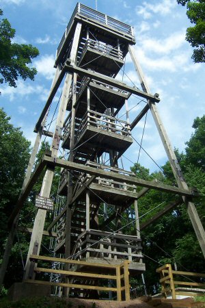 Photo: Bmwenner at English Wikipedia, Public domain (via Wikimedia Commons)
- 1,952 ft
- summit
- May–Oct
- best months
Timms Hill is a summit of 1,952 feet in Price County Forest in northern Wisconsin, about 5 miles from the town of Ogema. It sits within the forest's own land, and its elevation makes it a natural anchor for exploring the surrounding trails and waterways. Summer is the most comfortable time to visit. Typical averages from a nearby weather station at Prentice put July highs around 79°F with lows near 54°F, while winter highs stay in the 20s and lows dip to zero in January. That station sits about 400 feet lower than the summit, so temperatures on top run a little cooler. Several cross-country ski routes lie within about 6 miles, including Timm's Hill Trail, Beginner Loop and Jammer. For hiking, the Iat - Rib Lake Segment is about 7.6 miles away, and paddlers can reach the South Fork Jump River at roughly 9 miles.
Conditions and forecast
Daily highs and lows, wind and the chance of precipitation at the summit for the next 7 days, from the Open-Meteo model.
- Summit elevation
- 1,952 ft
Elevation from USGS 3D Elevation Program terrain data (about 10 m resolution).
We don't know of a mapped trail or route to the summit of Timms Hill. Plan the approach with local maps, a guidebook or a local guide, and check conditions before you go.
Questions about Timms Hill
How tall is Timms Hill?
1,952 ft (595 m).
Is there a trail to the top of Timms Hill?
We don't know of a mapped trail or route to the summit. Plan the approach with local maps, a guidebook or a local guide.
- Lookout Mountain1,947 ft · Wisconsin1 route35 mi away
 Rib Mountain1,920 ft · Wisconsin2 routes44 mi awayPhoto: Geography21, CC BY-SA 3.0 (via Wikimedia Commons)
- Maple Hill1,212 ft · Wisconsin3 routes52 mi away
- Saint Peters Dome1,568 ft · Wisconsin1 route71 mi away
- Bald Mountain1,319 ft · Michigan1 route77 mi away
- Point Mountain1,245 ft · Michigan1 route78 mi away
- Timm's Hill TrailCross-country skiing5.9 mi
- Beginner LoopCross-country skiing6 mi
- JammerCross-country skiing6.1 mi
- SkidderCross-country skiing6.1 mi
- Nordic TrailCross-country skiing6.3 mi
- Roller CoasterCross-country skiing6.4 mi
- Iat - Rib Lake SegmentHiking7.6 mi
- South Fork Jump RiverCanoeing9.1 mi
Source: Roamze catalog (indexable pages within 10 miles, PostGIS distance)
Best time to visit Timms Hill
Best months: May–October. Best months have typical highs of 55–85 °F, lows of 30 °F or warmer (32 °F where the station doesn't record snow), at most one snowy day and no more than 12 wet days.
Jan
21° / 0°
8 wet
Feb
27° / 3°
6 wet
Mar
39° / 15°
7 wet
Apr
52° / 29°
9 wet
May
66° / 41°
10 wet
Jun
75° / 51°
11 wet
Jul
79° / 54°
10 wet
Aug
77° / 52°
9 wet
Sep
69° / 45°
9 wet
Oct
55° / 33°
9 wet
Nov
39° / 21°
7 wet
Dec
26° / 9°
8 wet
Typical high / low (°F) and days with rain or snow, 1991–2020. Measured at Prentice #2, WI, 8.3 mi away at 1,540 ft. This station doesn't record snowfall. Source: NOAA NCEI U.S. Climate Normals 1991–2020.
