Mountain · 1 route
Sheep Rock
3,333 ft · North Carolina
- Summit
- 3,333 ft
- Routes
- 1 way up
About Sheep Rock
Sheep Rock is a summit of 3,333 feet in the Pisgah Ranger District of the National Forests in North Carolina, about 3.8 miles from the community of Bent Creek. For comfortable weather, aim for late spring or early fall. Typical averages from a nearby weather station in Candler run from highs around 75°F in May to about 77°F in September, and that station sits roughly 1,093 feet below the summit, so temperatures on top run cooler. The closest outing is the Brown Knob Trail, about half a mile away, and the Greens Lick Trail for mountain biking is about 1.3 miles off. Within about four miles you'll also find Lake Powhatan Glamping for lake fishing and Stony Bald for rock climbing.
Forecast on Sheep Rock
Daily highs and lows, wind and the chance of precipitation at the summit and route start for the next 7 days, from the Open-Meteo model.
Questions about Sheep Rock
How tall is Sheep Rock?
3,333 ft (1,016 m).
How many routes go to the summit of Sheep Rock?
One: brown knob trail.
Mountains nearby
- Billy Cove Knob3,759 ft · North Carolina1 route0.7 mi away
- Cold Knob3,614 ft · North Carolina2 routes2.4 mi away
- Wolf Knob3,241 ft · North Carolina1 route2.4 mi away
- Pine Mountain3,711 ft · North Carolina2 routes3.0 mi away
- Grassy Knob3,318 ft · North Carolina1 route3.1 mi away
- Double Head3,674 ft · North Carolina2 routes3.4 mi away
Facts about this place
When to go
Best time to go: Apr–Oct. The mildest months here, with typical highs of 68–83°F and lows of 41–62°F.
Typical monthly averages (not a forecast) from the Candler 1 W, NC weather station, 4.4 mi away. High / low in °F.
- Jan48° high25° low
- Feb52° high28° low
- Mar59° high34° low
- Apr68° high41° low
- May75° high50° low
- Jun81° high58° low
- Jul83° high62° low
- Aug82° high61° low
- Sep77° high55° low
- Oct68° high43° low
- Nov59° high33° low
- Dec51° high28° low
The station sits about 1,100 ft lower than this spot, so expect it to run cooler up here.
Where it is
- Pisgah Ranger District · Ranger district
- National Forests in North Carolina · National forest
- Nearest town
- Bent Creek, North Carolina · 3.8 mi
Conditions
Active alerts for Pisgah Ranger District as of Oct 9, 2026:
Pisgah Ranger District Bear Canister Requirement
information · posted Aug 24, 2026
Graveyard Field Camping Prohibitions- Pisgah Ranger District
information · posted Aug 24, 2026
Pisgah Ranger District Bear Canister Requirement- Pisgah Ranger District
information · posted Aug 24, 2026
Pisgah Ranger District Alcohol Restrictions- Pisgah Ranger District
information · posted Aug 24, 2026
Pisgah Ranger District Camping Restrictions Closure Order- Pisgah Ranger District
information · posted Aug 24, 2026
Pisgah Ranger District Dispersed Camping Regulations
information · posted Aug 24, 2026
Source: USFS forest alerts
Nearby
- brown knob trailHiking0.5 mi
- Greens Lick TrailMountain biking1.3 mi
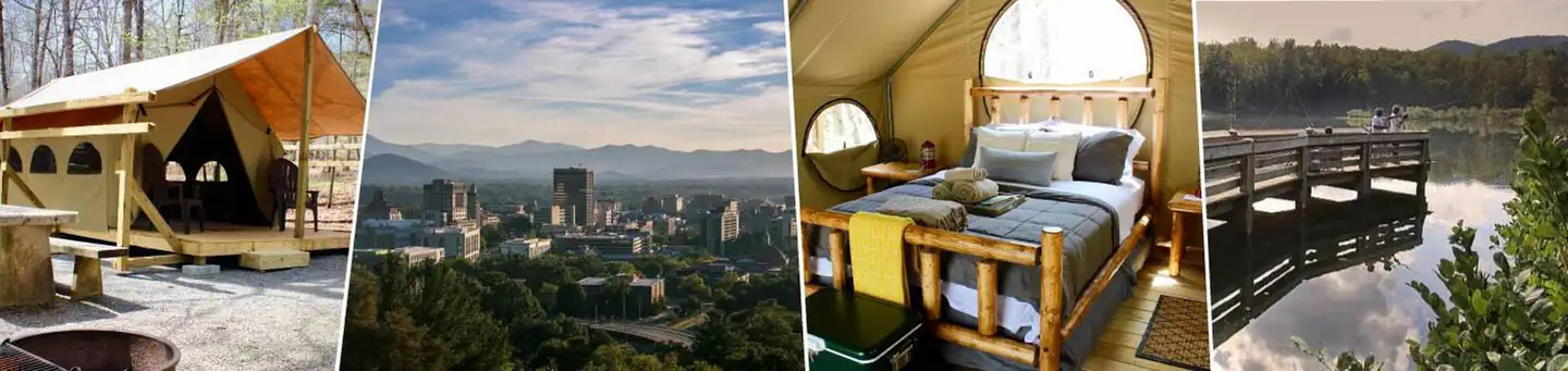 Lake Powhatan GlampingLake fishing2.7 mi
- Wash Creek Horse CampCamping4.1 mi
 Hendersonville Reservoir Rd Roadside CampsitesCampingPhoto: w_lemay, CC BY-SA 2.0 (via Wikimedia Commons)4.3 mi
- South Hominy CreekCanoeing4.4 mi
- Stony BaldRock climbing4.5 mi
- First BouldersRock climbing4.5 mi
Source: Roamze catalog (indexable pages within 10 miles, PostGIS distance)
Is Sheep Rock open right now?
Closure in the area
There's a closure order in National Forests in North Carolina. It doesn't name Sheep Rock, so check the source for the area it covers (2 listed).
Rainbow Springs Road closed for reconstruction
Agency closure covering National Forests in North Carolina · USFS · National Forests in North Carolina
Closures in anticipation of Hurricane Isaias
Agency closure covering National Forests in North Carolina · USFS · National Forests in North Carolina
Siddie Fields Day Use Area closed for improvements
Agency alert covering National Forests in North Carolina · USFS · National Forests in North Carolina
Pisgah National Forest Driving Safety Alert
Agency alert covering National Forests in North Carolina · USFS · National Forests in North Carolina
As of · Source: USFS · National Forests in North Carolina. Agencies don't list every closure — check before you go.
Best time to visit Sheep Rock
Best months: March–May and September–November. Best months have typical highs of 55–85 °F, lows of 30 °F or warmer (32 °F where the station doesn't record snow), at most one snowy day and no more than 12 wet days.
Jan
48° / 25°
10 wet
Feb
52° / 28°
10 wet
Mar
59° / 34°
12 wet
Apr
68° / 41°
11 wet
May
75° / 50°
12 wet
Jun
81° / 58°
13 wet
Jul
83° / 62°
14 wet
Aug
82° / 61°
13 wet
Sep
77° / 55°
10 wet
Oct
68° / 43°
9 wet
Nov
59° / 33°
9 wet
Dec
51° / 28°
10 wet
Typical high / low (°F) and days with rain or snow, 1991–2020. Measured at Candler 1 W, NC, 4.4 mi away at 2,240 ft. The station sits about 1,100 ft lower than this place, so expect it a little cooler here. This station doesn't record snowfall. Source: NOAA NCEI U.S. Climate Normals 1991–2020.
