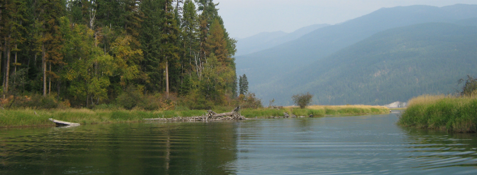
South Fork Flathead River
 Photo: Public domain (via Wikimedia Commons)
- 0.3 mi
- distance
- 3,880 ft
- high point
- May–Oct
- best months
Is South Fork Flathead River open right now?
Alert in the area
The Forest Service lists 6 alerts for Flathead National Forest.
Ashley Lake North Campground Closure
Agency alert covering Flathead National Forest · Order 01-10- · USFS · Flathead National Forest
Camp Creek Fire Updated Trail Closure
Agency alert covering Flathead National Forest · Order 01-10- · USFS · Flathead National Forest
FK&L Area Closed to Public Access Starting July 22, 2026
Agency alert covering Flathead National Forest · Order 01-10- · USFS · Flathead National Forest
Trail 800 Tally-Ashely Closure
Agency alert covering Flathead National Forest · Order 01-10- · USFS · Flathead National Forest
Ryan Creek Occupancy and Use Order
Agency alert covering Flathead National Forest · Order 1-10- · USFS · Flathead National Forest
As of · Source: USFS · Flathead National Forest. Agencies don't list every closure — check before you go.
The South Fork Flathead River is a 0.3-mile paddling stretch near Essex, Montana, set within the Spotted Bear Ranger District of Flathead National Forest. The Forest Service manages the land along this stretch of water, and the river flows year-round. USGS models put its average flow at about 2,174 cubic feet per second. Summer is the most comfortable time to paddle. Typical averages from a nearby weather station show July and August highs around 82°F with lows in the upper 40s, while winter highs stay in the 30s. Meadow Creek Gorge is just 0.1 mile away, and the Wagon Trail AT Meadow mountain biking route is 0.2 mile off. Beaver Creek Campground sits about 6.5 miles away, and Gorge Creek offers more canoeing roughly 7.4 miles out.
Local outfitters
- Bigfork Outdoor Rentals34 mi away
- Wild Horse RV Resort41 mi away
Not on Roamze yet. Their page has how to reach them.
- Meadow Creek GorgeHiking0.1 mi
- Wagon Trail AT MeadowMountain biking0.2 mi
- Meadow Cr Airstrip ShortcutMountain biking0.3 mi
- Main South ForkHiking0.9 mi
- Beaver Creek CampgroundCamping6.5 mi
- Gorge CreekCanoeing7.4 mi
- Spotted Bear CampgroundCamping8.2 mi
- Silvertip CabinCamping8.8 mi
Source: Roamze catalog (indexable pages within 10 miles, PostGIS distance)
 Middle Fork Flathead RiverCanoeing · ~34 min drivePhoto: US Geological Survey, Public domain (via Wikimedia Commons)
- Crossover Boat RampBoat launch · ~25 min drive
- Swan Lake CampgroundStand up paddleboarding · ~36 min drive
 Swan RiverCanoeing · ~54 min drivePhoto: USFWS, Public domain (via Wikimedia Commons)
- Holland Lake Boating SiteBoat launch · ~49 min drive
 Sun RiverCanoeing · ~58 min drivePhoto: Qfl247 (Transferred by Citypeek/Original uploaded by Qfl247), CC BY-SA 3.0 (via Wikimedia Commons)
- Canyon Creek Boating SiteBoat launch · ~53 min drive
 Clearwater RiverCanoeing · ~1h 4m drivePhoto: Bswc blackfootchallenge, CC BY-SA 4.0 (via Wikimedia Commons)
- Essex River AccessBoat launch · ~54 min drive
 Two Medicine RiverCanoeing · ~1h 16m drivePhoto: Steve Wilson, CC BY-SA 2.0 (via Wikimedia Commons)
Best time to visit South Fork Flathead River
Best months: May–October. Best months have typical highs of 55–85 °F, lows of 30 °F or warmer (32 °F where the station doesn't record snow), at most one snowy day and no more than 12 wet days.
Jan
31° / 18°
Feb
36° / 18°
Mar
45° / 26°
Apr
54° / 31°
May
64° / 38°
Jun
71° / 44°
Jul
82° / 48°
Aug
82° / 46°
Sep
70° / 39°
Oct
55° / 32°
Nov
39° / 25°
Dec
30° / 20°
Typical high / low (°F) and days with rain or snow, 1991–2020. Measured at Swan Lake, MT, 20.3 mi away at 3,100 ft. The station sits about 800 ft lower than this place, so expect it a little cooler here. This station doesn't record snowfall. Source: NOAA NCEI U.S. Climate Normals 1991–2020.
