Gratiot Lake Overlook Trail
- 0.9 mi
- one way
- 342 ft
- climb
- 1,144 ft
- high point
- Point to point
- route
- May–Sep
- best months
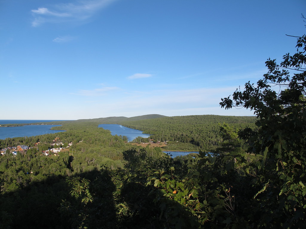
Gratiot Lake Overlook Trail is a short, easy hike of about 0.85 miles in Michigan, set on a route that rises from a low point of 762 feet to a high of 1,144 feet. It is a point-to-point walk, and the steepest part comes near the start, with a 20% grade at about 0.08 miles. The trail is rated easy and climbs about 342 feet one way. The nearest town is Nepco Camp Number 7, about 2.8 miles away. Summer is the most comfortable time to go. Typical averages from the nearby Copper Harbor weather station, which sits about 518 feet lower, put July and August highs around 72°F with lows in the upper 50s. Winter is harsh, with January highs near 26°F and lows around 15°F. The trip takes about half an hour, and the climb is front-loaded, so the hardest stretch is early on. Bikes are not allowed on the trail. Several other hikes lie within about 6 miles, including Cliff View Trail and Northwoods Trail. The Wellhead Loop cross-country ski trail is also close by, and climbers can head to the Cliff Dr. - Keweenaw County climbing area about 9.5 miles away.
Local outfitters
- Keweenaw Adventure Company14 mi away
Not on Roamze yet. Their page has how to reach them.
 Cliff View TrailHikingPhoto: Jim Sorbie, CC BY 2.0 (via Flickr)5.5 mi
- Northwoods TrailHikingPhoto: Jim Sorbie, CC BY 2.0 (via Flickr)5.6 mi
- Top of Hill HikeHikingPhoto: Jim Sorbie, CC BY 2.0 (via Flickr)5.9 mi
- Nicole Bloom Memorial TrailHiking6.1 mi
- 6Th Street TrailHiking6.1 mi
- Wellhead LoopCross-country skiing6.2 mi
- Shadow's ShortcutCross-country skiing6.4 mi
- Cliff Dr. - Keweenaw CountyRock climbing9.5 mi
Source: Roamze catalog (indexable pages within 10 miles, PostGIS distance)
- Cliff View TrailHiking · ~9 min drivePhoto: Jim Sorbie, CC BY 2.0 (via Flickr)
 WHITE DEER LAKEHiking · ~1h 25m drivePhoto: usfs_Eastern_Region, Public Domain Mark (via Flickr)
- Yellow Dog FallsHiking · ~1h 16m drive
- Northwoods TrailHiking · ~10 min drivePhoto: Jim Sorbie, CC BY 2.0 (via Flickr)
- Pelkie Creek HunterHiking · ~1h 23m drive
- Top of Hill HikeHiking · ~10 min drivePhoto: Jim Sorbie, CC BY 2.0 (via Flickr)
 Upson Lake TrailHiking · ~13 min drivePhoto: Joe Passe, CC BY-SA 2.0 (via Flickr)
- Keweenaw Shores TrailHiking · ~13 min drivePhoto: Joe Passe, CC BY-SA 2.0 (via Flickr)
 Rooks Memorial TrailHiking · ~22 min drivePhoto: StretchyBill, CC BY-SA 2.0 (via Flickr)
 Hunter's Point Hiking TrailHiking · ~23 min drivePhoto: Joe Passe, CC BY-SA 2.0 (via Flickr)
Best time to visit Gratiot Lake Overlook Trail
Best months: May–September. Best months have typical highs of 55–85 °F, lows of 30 °F or warmer (32 °F where the station doesn't record snow), at most one snowy day and no more than 12 wet days.
Jan
26° / 15°
15 wet
Feb
27° / 14°
11 wet
Mar
35° / 21°
9 wet
Apr
45° / 31°
10 wet
May
58° / 41°
11 wet
Jun
67° / 48°
11 wet
Jul
72° / 57°
10 wet
Aug
72° / 58°
9 wet
Sep
65° / 51°
11 wet
Oct
52° / 41°
15 wet
Nov
41° / 30°
15 wet
Dec
31° / 21°
16 wet
Typical high / low (°F) and days with rain or snow, 1991–2020. Measured at Copper Harbor, MI, 13.7 mi away at 626 ft. The station sits about 500 ft lower than this place, so expect it a little cooler here. This station doesn't record snowfall. Source: NOAA NCEI U.S. Climate Normals 1991–2020.
Map and trail data © OpenStreetMap contributors
