Profile Rock
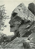 Photo: Unknown authorUnknown author, Public domain (via Wikimedia Commons)
- 179 ft
- summit
- Jun–Oct
- best months
Profile Rock is a summit in Bristol County, Massachusetts, rising to about 179 feet. The nearest town is Fall River, about 5 miles away. Late spring and early fall are the most comfortable times to visit. Typical averages from the nearby Taunton airport weather station run from highs around 70°F with lows in the mid-40s in May to highs around 75°F with lows near 51°F in September. For more time on the trail, Grinnel Path is about 3.5 miles away and Clark Field Path about 3.9 miles. Pine Tree Trail and Woodchuck Trail are both within 5 miles.
Conditions and forecast
Daily highs and lows, wind and the chance of precipitation at the summit for the next 7 days, from the Open-Meteo model.
- Summit elevation
- 179 ft
Elevation from USGS 3D Elevation Program terrain data (about 10 m resolution).
We don't know of a mapped trail or route to the summit of Profile Rock. Plan the approach with local maps, a guidebook or a local guide, and check conditions before you go.
Questions about Profile Rock
How tall is Profile Rock?
179 ft (55 m).
Is there a trail to the top of Profile Rock?
We don't know of a mapped trail or route to the summit. Plan the approach with local maps, a guidebook or a local guide.
- Grinnel PathHiking3.5 mi
- Clark Field PathHiking3.9 mi
- Pine Tree TrailHiking4.6 mi
- Woodchuck TrailHiking4.9 mi
- Canfield East Line TrailHiking5.1 mi
- Out and About TrailHiking5.7 mi
 Green TrailHikingPhoto: Massachusetts Dept. of Environmental Protection, CC BY 2.0 (via Flickr)7.3 mi
- Ridge LoopHiking7.8 mi
Source: Roamze catalog (indexable pages within 10 miles, PostGIS distance)
 Pigeon HillSummit · ~46 min drivePhoto: Davidafranklin, CC BY-SA 4.0 (via Wikimedia Commons)
 Great Blue HillSummit · ~50 min drivePhoto: The original uploader was Swampyank at English Wikipedia., Public domain (via Wikimedia Commons)
 Bearberry HillSummit · ~57 min drivePhoto: Larry D. Moore, CC BY 4.0 (via Wikimedia Commons)
 Jerimoth HillSummit · ~1h 5m drivePhoto: Khoule23 at English Wikipedia, Public domain (via Wikimedia Commons)
 Waitts MountainSummit · ~1h 16m drivePhoto: Thea Prum from Boston, USA, CC BY-SA 2.0 (via Wikimedia Commons)
- Ridge HillSummit · ~12 min drive
- Bourne HillSummit · ~33 min drive
- Coles HillSummit · ~40 min drive
- Waiting HillSummit · ~42 min drive
- Wolf HillSummit · ~43 min drive
Best time to visit Profile Rock
Best months: June–October. Best months have typical highs of 55–85 °F, lows of 30 °F or warmer (32 °F where the station doesn't record snow), at most one snowy day and no more than 12 wet days.
Jan
39° / 19°
11 wet
Feb
41° / 21°
10 wet
Mar
48° / 27°
12 wet
Apr
59° / 36°
13 wet
May
70° / 46°
13 wet
Jun
78° / 54°
12 wet
Jul
84° / 61°
12 wet
Aug
83° / 59°
12 wet
Sep
75° / 51°
12 wet
Oct
64° / 41°
12 wet
Nov
54° / 32°
11 wet
Dec
44° / 25°
12 wet
Typical high / low (°F) and days with rain or snow, 1991–2020. Measured at Taunton Muni Ap, MA, 5.8 mi away at 43 ft. This station doesn't record snowfall. Source: NOAA NCEI U.S. Climate Normals 1991–2020.
