Firetower Trail
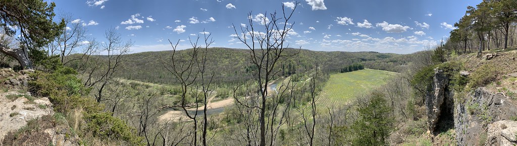 Photo: christinejwarner, CC BY 2.0 (via Flickr)
- 0.6 mi
- round trip
- 66 ft
- climb
- 1,063 ft
- high point
- Out and back
- route
- Apr–Oct
- best months
Firetower Trail is a short, easy hike in Yellow River State Forest in Iowa, managed by the State Department of Natural Resources. The trail is about 0.6 miles long and rises roughly 66 feet from its low point of 992 feet to a high of 1063 feet. It is an out-and-back route, and the whole trip covers about 1.2 miles. The trail is open to horses, and bikes are not allowed. That makes it a good choice for riders on horseback or for anyone who wants to keep the pace simple on foot. Late spring and early fall are the most comfortable times to go. Typical averages from a nearby weather station show May highs around 70°F and September highs around 73°F, with July the warmest month at about 82°F. That station sits several hundred feet lower than the trail, so temperatures on the trail run a little cooler. Several other trails start close by. Firetower Road is about 0.1 mile away, Cedar Point Overlook Rd. is about 0.2 mile away, and the Red Oak Loop Trail is about 0.3 mile away. For fishing, Paint Creek is about 3.7 miles away.
 Firetower RoadHikingPhoto: christinejwarner, CC BY 2.0 (via Flickr)0.1 mi
- Cedar Point Overlook Rd.HikingPhoto: christinejwarner, CC BY 2.0 (via Flickr)0.2 mi
- Firetower Rd./Brown's Hollow TrailHiking0.3 mi
- Red Oak Loop TrailHikingPhoto: christinejwarner, CC BY 2.0 (via Flickr)0.3 mi
 Cedar Point Overlook TrailHikingPhoto: christinejwarner, CC BY 2.0 (via Flickr)0.5 mi
 Firetower TrialHikingPhoto: christinejwarner, CC BY 2.0 (via Flickr)0.6 mi
 Day-Use RoadHikingPhoto: christinejwarner, CC BY 2.0 (via Flickr)0.7 mi
- Paint CreekRiver fishing3.7 mi
Source: Roamze catalog (indexable pages within 10 miles, PostGIS distance)
- Cedar Point Overlook Rd.Hiking · Next doorPhoto: christinejwarner, CC BY 2.0 (via Flickr)
- Red Oak Loop TrailHiking · Next doorPhoto: christinejwarner, CC BY 2.0 (via Flickr)
- Cedar Point Overlook TrailHiking · Next doorPhoto: christinejwarner, CC BY 2.0 (via Flickr)
- Firetower TrialHiking · ~1 min drivePhoto: christinejwarner, CC BY 2.0 (via Flickr)
- Day-Use RoadHiking · ~1 min drivePhoto: christinejwarner, CC BY 2.0 (via Flickr)
- White PineHiking · ~1 min drivePhoto: christinejwarner, CC BY 2.0 (via Flickr)
- Saddle Loop TrailHiking · ~2 min drivePhoto: christinejwarner, CC BY 2.0 (via Flickr)
- Donahue RoadHiking · ~2 min drivePhoto: christinejwarner, CC BY 2.0 (via Flickr)
- Nelson Bridge LoopHiking · ~2 min drivePhoto: christinejwarner, CC BY 2.0 (via Flickr)
- Paint Creek TrailHiking · ~2 min drivePhoto: christinejwarner, CC BY 2.0 (via Flickr)
Best time to visit Firetower Trail
Best months: April–October. Best months have typical highs of 55–85 °F, lows of 30 °F or warmer (32 °F where the station doesn't record snow), at most one snowy day and no more than 12 wet days.
Jan
27° / 10°
9 wet
Feb
31° / 13°
8 wet
Mar
44° / 25°
9 wet
Apr
58° / 37°
11 wet
May
70° / 49°
12 wet
Jun
79° / 59°
12 wet
Jul
82° / 63°
10 wet
Aug
80° / 61°
9 wet
Sep
73° / 53°
9 wet
Oct
60° / 41°
9 wet
Nov
44° / 29°
8 wet
Dec
32° / 17°
9 wet
Typical high / low (°F) and days with rain or snow, 1991–2020. Measured at Lynxville Dam 9, WI, 8.1 mi away at 633 ft. This station doesn't record snowfall. Source: NOAA NCEI U.S. Climate Normals 1991–2020.
