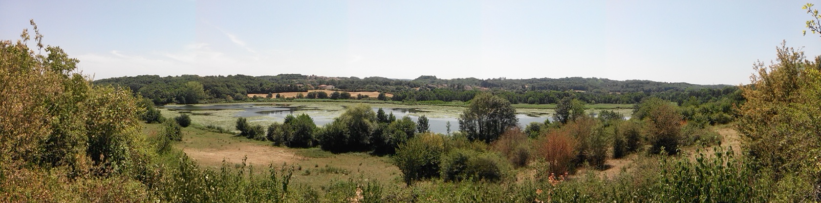
Réserve naturelle des étangs de Mépieu
 Photo: This picture belongs to Xavier Caré.
Please credit : Xavier Caré / Wikimedia Commons / CC-BY-SA.
If you would like special permission to use, license, or purchase the image please contact me to negotiate terms.
I'd appreciate if you could let me know about it or mail me ( xavier.carepm.me) if you want to use this picture out of the Wikimedia project scope., CC BY-SA 4.0 (via Wikimedia Commons)
- Jun–Sep
- best months
Réserve naturelle des étangs de Mépieu is a protected natural area in Auvergne-Rhône-Alpes, France, covering about 400 acres (2 km²). It is on the edge of Mépieu. It was established in 2008. It is classed as a regional nature reserve. It is managed as an IUCN category IV protected area. These details come from Wikidata. The boundary comes from OpenStreetMap. Check the park's own rules, fees and opening hours before you go.
Conditions and forecast
Daily highs and lows, wind and the chance of precipitation at Réserve naturelle des étangs de Mépieu for the next 7 days, from the Open-Meteo model.
Park size
411 acres
 Réserve naturelle nationale du Haut-Rhône françaisState park · ~13 min drivePhoto: Stéphane Batigne, CC BY 3.0 (via Wikimedia Commons)
 Réserve naturelle de l'étang de Saint-BonnetState park · ~28 min drivePhoto: Freezed, CC BY-SA 3.0 (via Wikimedia Commons)
 Réserve naturelle du marais de LavoursState park · ~28 min drivePhoto: Delorme, CC BY-SA 3.0 (via Wikimedia Commons)
 Réserve naturelle régionale du lac d'AiguebeletteState park · ~37 min drivePhoto: Jean-Pierre Couffinhal, CC BY-SA 3.0 (via Wikimedia Commons)
 Réserve naturelle de l'étang du Grand-LempsState park · ~38 min drivePhoto: Greg MAILLET, CC BY-SA 3.0 (via Wikimedia Commons)
 Zone humide du Triangle de Terre-NueState park · ~39 min drivePhoto: Florian Pépellin, CC BY-SA 4.0 (via Wikimedia Commons)
 Espace naturel sensible de l'étang du Grand BirieuxState park · ~42 min drivePhoto: Eichler, Andreas, CC BY-SA 4.0 (via Wikimedia Commons)
 Parc naturel régional de ChartreuseState park · ~48 min drivePhoto: No machine-readable author provided. Gemini1980 assumed (based on copyright claims)., Public domain (via Wikimedia Commons)
 Espace Naturel Sensible du Domaine de VernangeState park · ~48 min drivePhoto: Benoît Prieur, CC0 (via Wikimedia Commons)
 Réserve Protégée de la Tourbière des CreusatesState park · ~49 min drivePhoto: Guilhem Vellut from Annecy, France, CC BY 2.0 (via Wikimedia Commons)
Also worth it near here
- Port Saint JeanBoat launch · ~8 min drive
 Cascade de LuizetWaterfall · ~12 min drivePhoto: Caboulot, CC0 (via Wikimedia Commons)
 Le Mont PelaSummit · ~13 min drivePhoto: Rémih, CC BY-SA 4.0 (via Wikimedia Commons)
 Plage de Saint-Maurice-de-GourdansBeach · ~22 min drivePhoto: Sebleouf, CC BY-SA 4.0 (via Wikimedia Commons)
 Les Plages de l'AinCamping · ~23 min drivePhoto: Sebleouf, CC BY-SA 4.0 (via Wikimedia Commons)
Best time to visit Réserve naturelle des étangs de Mépieu
Best months: June–September. Best months have typical highs of 55–85 °F, lows of 30 °F or warmer (32 °F where there's no snowfall data), at most one snowy day and no more than 12 wet days.
Jan
43° / 30°
14 wet
Feb
46° / 32°
12 wet
Mar
54° / 37°
13 wet
Apr
59° / 42°
15 wet
May
67° / 50°
15 wet
Jun
74° / 56°
12 wet
Jul
79° / 61°
11 wet
Aug
78° / 61°
11 wet
Sep
70° / 54°
12 wet
Oct
62° / 47°
14 wet
Nov
50° / 37°
14 wet
Dec
43° / 32°
15 wet
Typical high / low (°F) and days with rain or snow, 1981–2010. Modelled for the 1 km square this place sits in (average height 853 ft), not measured at a weather station. We don't have this place's elevation, so higher spots nearby can run cooler. Snowfall days aren't in this data. Source: CHELSA 1 km climate model (1981–2010) and CRU TS 4.09 wet days. Data: CHELSA V2.1 climatologies (Karger et al. 2017), WSL (CC0 1.0); CRU TS 4.09 (Harris et al. 2020), University of East Anglia Climatic Research Unit. Contains public sector information licensed under the Open Government Licence v3.0. (Open Government Licence v3.0).
Map and trail data © OpenStreetMap contributors
