Lewis
Foresthill, California
Free — you'll pick up right here.
No verdict for this campground
We won't guess. Here is exactly what we do and don't know.
What we do know
Inside Tahoe National Forest
2 managing-area boundaries mapped — agency alerts for them feed this page automatically.
Boundary data
What's missing
No access route mapped
We don't yet know which road reaches this trailhead, so we can't tell you if it's gated.
Nobody's filed a report here yet — be the first.
Campsite availability
Live from Recreation.gov for Lewis.
Here's your stay, mapped
Lewis
Suggested plan · check conditions before you go
Gear for the day
Meals
Photos
About this campground
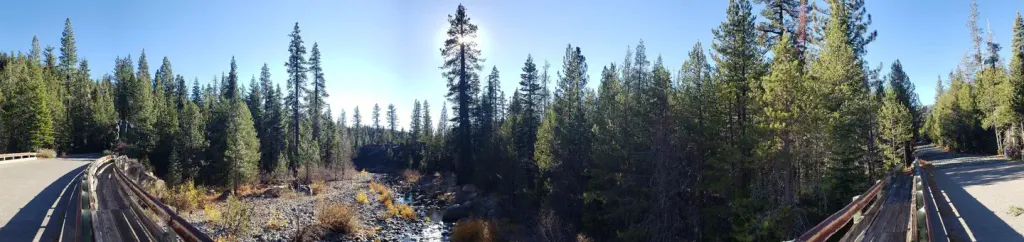
Overview Lewis Campground is located on French Meadows Reservoir in the Tahoe National Forest, 40 miles east Foresthill. Visitors enjoy the area for its fishing, boating and trail opportunities. Recreation Popular activities on the reservoir include boating, canoeing, fishing and swimming. McGuire boat ramp is located within a mile of the campground. The Middle Fork American River can be accessed nearby and provides fishing and swimming. A variety of hiking and biking trails are found in the surrounding area, including the Western States Trail, Tevis Cup Trail, and some that provide access to the nearby Granite Chief Wilderness. Facilities The campground offers single-family campsites, a few of which are accessible. Each site is equipped with a picnic table and a grill. Flush and vault toilets and drinking water are provided. Roads and parking spurs are paved. Natural Features The campground sits on the north shore of French Meadows Reservoir in a coniferous forest. The reservoir is on the Middle Fork of the American River and is the western gateway to the Granite Chief Wilderness. Nearby Attractions Lewis Campground is a recreation site within the French Meadows Recreation Area which includes many other recreation facilities. The Granite Chief Wilderness can be accessed nearby at Talbot Trailhead and access to the Western States Trail and Tevis Cup Trail also can be accessed nearby. Other recreation opportunities include many hiking, equestrian, mountain biking, and motorcycle singletrack trails, Duncan Canyon, Duncan Peak Lookout, Robinson Flat historic ranger station, Placer County Big Tree Grove Botanical Area, and Grouse Falls Scenic Area.
Directions & GPX
Facts about this campground
When to go
Typical monthly averages (not a forecast) from the Lake Spaulding, CA weather station, 18 mi away. High / low in °F.
- Jan44° high25° low
- Feb46° high26° low
- Mar51° high27° low
- Apr56° high30° low
- May64° high37° low
- Jun75° high43° low
- Jul82° high48° low
- Aug82° high47° low
- Sep76° high44° low
- Oct65° high37° low
- Nov51° high30° low
- Dec43° high25° low
Where it is
- American River Ranger District · Ranger district
- Tahoe National Forest · National forest
- Managed by
- Forest Service
Conditions
Active alerts for Tahoe National Forest as of Oct 9, 2026:
information · posted Oct 5, 2026
fire-restriction · posted Sep 28, 2026
information · posted Sep 25, 2026
Hoke Valley- Forest Road 860-07 (17E11 Trail) Closed
information · posted Aug 24, 2026
Highway 20 Area Camping Restrictions
information · posted Aug 24, 2026
Camping and Campfire Restrictions-Truckee and Sierraville Districts
fire-restriction · posted Aug 24, 2026
Sierraville Ranger District Trail Closure
information · posted Aug 24, 2026
information · posted Aug 24, 2026
14-day Camping Occupancy Restrictions
information · posted Aug 24, 2026
information · posted Aug 24, 2026
Source: USFS forest alerts
Nearby
- Coyote GroupCamping0.4 mi
- Gates GroupCamping0.8 mi
- Middle Fork American RiverCanoeing2.5 mi
- Placer Queen Mine TrailHiking3.3 mi
- Western States TrailHiking3.5 mi
- Duncan CreekCanoeing4.6 mi
- Center WallRock climbing9.5 mi
- Shirley Canyon CliffsRock climbing9.8 mi
Source: Roamze catalog (indexable pages within 10 miles, PostGIS distance)
Add to a trip & share
Keep exploring — more campsites worth the drive
Coyote Group
~1 min drive
A worthwhile stop near California.
Gates Group
~1 min drive
A worthwhile stop near California.
Ahart Cg
~2 min drive
A worthwhile stop near California.
Handy Camp
~6 min drive
Handy Camp is a campground in California at about 5,543 feet. It is managed by the U.S. Forest Service.
Robinson Flat
~8 min drive
A worthwhile stop near California.
Little American Valley
~10 min drive
Little American Valley is a campground in California with 25 sites.
Picayune
~11 min drive
Picayune is a campground in California with 30 sites.
Palisade Creek Trailhead
~12 min drive
Palisade Creek Trailhead is a campground in California at about 6,278 feet. It is managed by the U.S. Forest Service.
Little Needle Lake
~12 min drive
Little Needle Lake is a California campground with 10 sites.
Tadpole Campground
~13 min drive
Tadpole Campground is a campground in California at about 6,473 feet. It is managed by the U.S. Forest Service.
Also worth it near here


