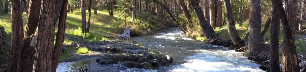
Hat Creek
FALL RIVER MILLS, California
Free — you'll pick up right here.
No verdict for this campground
We won't guess. Here is exactly what we do and don't know.
What we do know
Inside Lassen National Forest
2 managing-area boundaries mapped — agency alerts for them feed this page automatically.
Boundary data
What's missing
No access route mapped
We don't yet know which road reaches this trailhead, so we can't tell you if it's gated.
Nobody's filed a report here yet — be the first.
Campsite availability
Live from Recreation.gov for Hat Creek.
Here's your stay, mapped
Hat Creek
Suggested plan · check conditions before you go
Gear for the day
Meals
Photos
About this campground
Overview Hat Creek is one of six campgrounds available in the Hat Creek Recreation Area, home to some of the area's best trout fishing. Scenic hiking trails and an active volcanic area can easily be accessed from the facility. Recreation Hat Creek is popular for its trophy trout fishing. The cold waters of the creek allow for a refreshing play on hot summer days. Other popular activities in the area include wildlife viewing, hunting, backpacking, hiking and caving. A variety of day hikes are available in the area, including the Spatter Cones Nature Trail, which is located just across the highway from the campground. The 1.5-mile loop trail provides hikers with a unique opportunity to explore craters, cones and crevices, as well as other geologic features left by the Hat Creek Lava Flow. Nearby, visitors can take a self-guided tour of Subway Cave. The trail is less than a half-mile long and explores the underground world of a lava tube. Visitors are encouraged to bring flashlights for hiking through the cave. Facilities Hat Creek offers three group campsites that can accommodate up to 50 people each. Individual sites are also available on a first-come, first-served basis. Picnic tables and campfire rings with grills are provided, as are accessible flush and vault toilets, utility sinks and drinking water. The RV dump-station is located 1.5 miles north of the campground behind the Old Station Visitors Center. Natural Features The campground is situated next to Hat Creek in a mixed conifer forest at an elevation of about 4,390 feet. Pine needles, grasses and volcanic rocks cover the forest floor. Sites are widely spaced for privacy. Nearby Attractions The campground is located about a mile west of the town of Old Station, and 12 miles east of the northwest entrance to Lassen Volcanic National Park, where active, hissing fumaroles and boiling mud pots are continually shaping the landscape. The Pacific Crest National Scenic Trail can be accessed near the Spatter Cones Nature Trailhead.
Directions & GPX
Facts about this campground
When to go
Typical monthly averages (not a forecast) from the Manzanita Lake, CA weather station, 11 mi away. High / low in °F.
- Jan41° high22° low
- Feb42° high22° low
- Mar46° high24° low
- Apr50° high27° low
- May61° high35° low
- Jun70° high41° low
- Jul79° high46° low
- Aug78° high45° low
- Sep72° high41° low
- Oct59° high33° low
- Nov47° high26° low
- Dec39° high22° low
The station sits about 1,300 ft higher than this spot, so expect it to run a little warmer here.
Where it is
- Hat Creek Ranger District · Ranger district
- Lassen National Forest · National forest
- Nearest town
- Old Station, California · 0.9 mi
- Managed by
- Forest Service
Source: USFS EDW boundaries; USGS PAD-US 4.1; USGS GNIS populated places
Conditions
Active alerts for Lassen National Forest as of Oct 10, 2026:
SAFETY ALERT - South Antelope Bridge out, Do Not Cross
critical · posted Aug 24, 2026
critical · posted Aug 24, 2026
Lassen National Forest Camping Restrictions
information · posted Aug 24, 2026
Lake Almanor Area Camping Restriction
information · posted Aug 24, 2026
Lake Almanor Recreational Trail Restriction
information · posted Aug 24, 2026
Source: USFS forest alerts
Nearby
- Spattercone Crest TrailHiking0.2 mi
- Potato Butte 6Hiking0.7 mi
- Cave CampgroundCamping1.7 mi
- Subway Cave Interpretive TrailHiking1.8 mi
- Big PineCamping2.6 mi
- RockyCamping4.1 mi
- Plum ValleyRock climbing4.5 mi
- Finger Rake AreaRock climbing9.8 mi
Source: Roamze catalog (indexable pages within 10 miles, PostGIS distance)
Add to a trip & share
Keep exploring — more campsites worth the drive
Lost Creek Group
~14 min drive
A worthwhile stop near California.
Butte Lake Stock Corral
~18 min drive
A worthwhile stop near California.
Butte Lake Group
~18 min drive
A worthwhile stop near California.
Butte Lake
~18 min drive
A worthwhile stop near California.
Manzanita Lake
~20 min drive
A worthwhile stop near California.
Summit Lake North
~21 min drive
A worthwhile stop near California.
Summit Lake Stock Corral
~21 min drive
A worthwhile stop near California.
Summit Lake South
~21 min drive
A worthwhile stop near California.
Juniper Lake Stock Corral
~29 min drive
A worthwhile stop near California.
Juniper Lake Group
~29 min drive
A worthwhile stop near California.
Also worth it near here
 Photo: BoltSnypr, CC BY 3.0 (via Wikimedia Commons)
Subway Cave Interpretive Trail
~3 min drive
Restroom
~3 min drive
 Photo: Clyde Charles Brown, CC BY-SA 4.0 (via Wikimedia Commons)
Badger Mountain
~11 min drive
 Photo: randomduck, CC BY-SA 2.0 (via Flickr)
Roadside Distraction
~17 min drive
Butte Lake Group
~18 min drive
