South Shore Campground
California
Free — you'll pick up right here.
Conditions: Caution
for campground, todayAgency alerts are in effect for this area; weather is good
2 factors · 2 sources
Newest 10 h ago · oldest 10 h
caution: Agency alerts
13 active alerts in Eldorado National Forest; most severe: Fire Restrictions are in Effect Forest Wide
USFSPosted Sep 22 · checked 10 h ago
clear: Weather
Clouds, high 76°F / low 55°F, 0% precip — 98/100 for campground
OpenWeather10 h ago
Been out here in the last few days? One report keeps this current for everyone.
Campsite availability
Live from Recreation.gov for South Shore Campground.
Here's your stay, mapped
South Shore Campground
Suggested plan · check conditions before you go
Gear for the day
Meals
Photos
About this campground
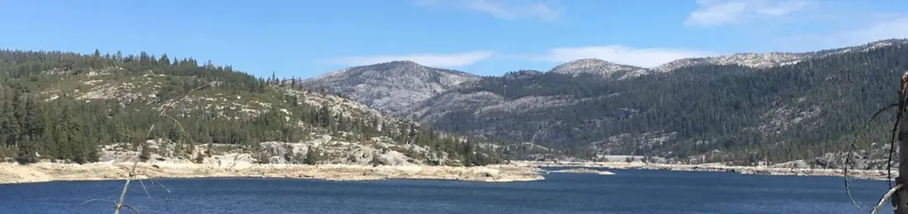
Overview South Shore Campground is located next to Lower Bear River Reservoir in the Eldorado National Forest the central Sierra Nevada Mountains. It's a prime location for fishing and boating. Recreation Lower Bear Reservoir covers 166 acres and has 2.5 miles of shoreline. Activities include fishing, swimming, boating, canoeing and picnicking. Anglers may catch rainbow, brown and mackinaw trout. A boat ramp is located within a mile of the campground. The Pardoe Trail can be accessed a short distance past nearby Upper Bear River Reservoir, and borders Mokelumne Wilderness. Facilities Each campsite comes with a picnic table and grill. One campsite is accessible, as is one of the vault toilets. Drinking water is provided. A general store is about a mile from the campground on the northern part of the reservoir. Natural Features The campground is nestled in a mixed conifer forest on a hillside just above the south shore of Lower Bear River Reservoir at an elevation of 5,900 feet. Some campsites offer partial views of the lake through the trees. A Mediterranean climate extends over most of the forest, with warm, dry summers and cold, wet winters. Charges & Cancellations Recreation Fee: Recreation fees are the fees a visitor pays for things like overnight camping, a day-use pavilion, group facilities, a tour or a permit. Recreation fees vary by location and/or activity. Reservation Fee: A fee may be charged at the time a reservation is made to cover the cost of reservation services. This fee is in addition to the Recreation Fee and is non-refundable. Fees for camping, day use, group sites, cabins and lookouts: $8 if made on-line; $9 if made through the call center; $3 if made in-person. Change Fee: A service fee may be charged at the time a modification is made depending on the changes. Cancellation Fee: A $10 service fee will be withheld from any refunds for a cancelled reservation. Cut-Off Window: The latest date and/or time that you can make an advanced reservation or a change to an existing reservation. Cut-off windows can vary by location, but are typically 4 days before your arrival date. A customer who cancels a reservation the day before or on the day of arrival will pay a $10.00 service fee AND forfeit the first night's use fee (see Late Cancellation below). Late Cancellation: If you cancel your reservation too close to the start date, additional service fees may be withheld.
Directions & GPX
Facts about this campground
When to go
Typical monthly averages (not a forecast) from the South Lake Tahoe Ap, CA weather station, 28 mi away. High / low in °F.
- Jan43° high18° low
- Feb43° high19° low
- Mar48° high24° low
- Apr53° high28° low
- May62° high33° low
- Jun72° high38° low
- Jul80° high43° low
- Aug80° high41° low
- Sep73° high35° low
- Oct62° high29° low
- Nov51° high23° low
- Dec43° high18° low
Where it is
- Amador Ranger District · Ranger district
- Eldorado National Forest · National forest
- Managed by
- Forest Service
Conditions
Active alerts for Eldorado National Forest as of Oct 9, 2026:
Fire Restrictions are in Effect Forest Wide
fire-restriction · posted Sep 30, 2026
information · posted Aug 24, 2026
Mokelumne Wilderness Restricted Use
information · posted Aug 24, 2026
Occupancy and Use Restrictions - Desolation Wilderness Area
information · posted Aug 24, 2026
Deer Valley Trail (19E01) & Meadow Lake Road (09N01)
caution · posted Aug 24, 2026
Silver Bear Wheeled Vehicle Closure
information · posted Aug 24, 2026
Desolation Wilderness Food and Refuse Storage Restriction
information · posted Aug 24, 2026
Camping Occupancy Restrictions
information · posted Aug 24, 2026
information · posted Aug 24, 2026
Help Halt Golden Mussel Invasion
caution · posted Aug 24, 2026
Source: USFS forest alerts
Nearby
- Cole Creek LoopCross-country skiing0.2 mi
- Pardoes Point CampgroundCamping0.3 mi
- Bear River Group Campground (Eldorado National Forest, CA)Camping0.9 mi
- SALT SPRS. OVERLOOKHiking1.5 mi
- Gamma QuadrantRock climbing1.7 mi
- Alpha QuadrantRock climbing1.8 mi
- Bear RiverCanoeing3 mi
- Cole CreekCanoeing3.7 mi
Source: Roamze catalog (indexable pages within 10 miles, PostGIS distance)
Add to a trip & share
Keep exploring — more campsites worth the drive
Bear River Group Campground (Eldorado National Forest, CA)
~1 min drive
A worthwhile stop near California.
Pipi Campground
~19 min drive
A worthwhile stop near California.
 Photo: Ken Lund — CC BY-SA 2.0 (via Flickr)
Silver Lake Cg
~20 min drive
A worthwhile stop near California.
Capps Crossing
~21 min drive
A worthwhile stop near California.
Pardoes Point Campground
~0 min drive
A worthwhile stop near California.
Shriner Lake Campground
~7 min drive
A worthwhile stop near California.
Moore Creek
~7 min drive
Moore Creek is a campground in California with 100 sites.
Horse Gulch Campground
~13 min drive
A worthwhile stop near California.
Ridge Camp
~18 min drive
Ridge Camp is a campground in California at about 7,389 feet. It is managed by the U.S. Forest Service.
Big Meadow Campground
~18 min drive
Big Meadow Campground is a campground in California at about 6,537 feet. It is managed by the U.S. Forest Service.

